


- News
- E-mail list
- Signup for our newsletter
- Stentec news
- News
- Developers Blog
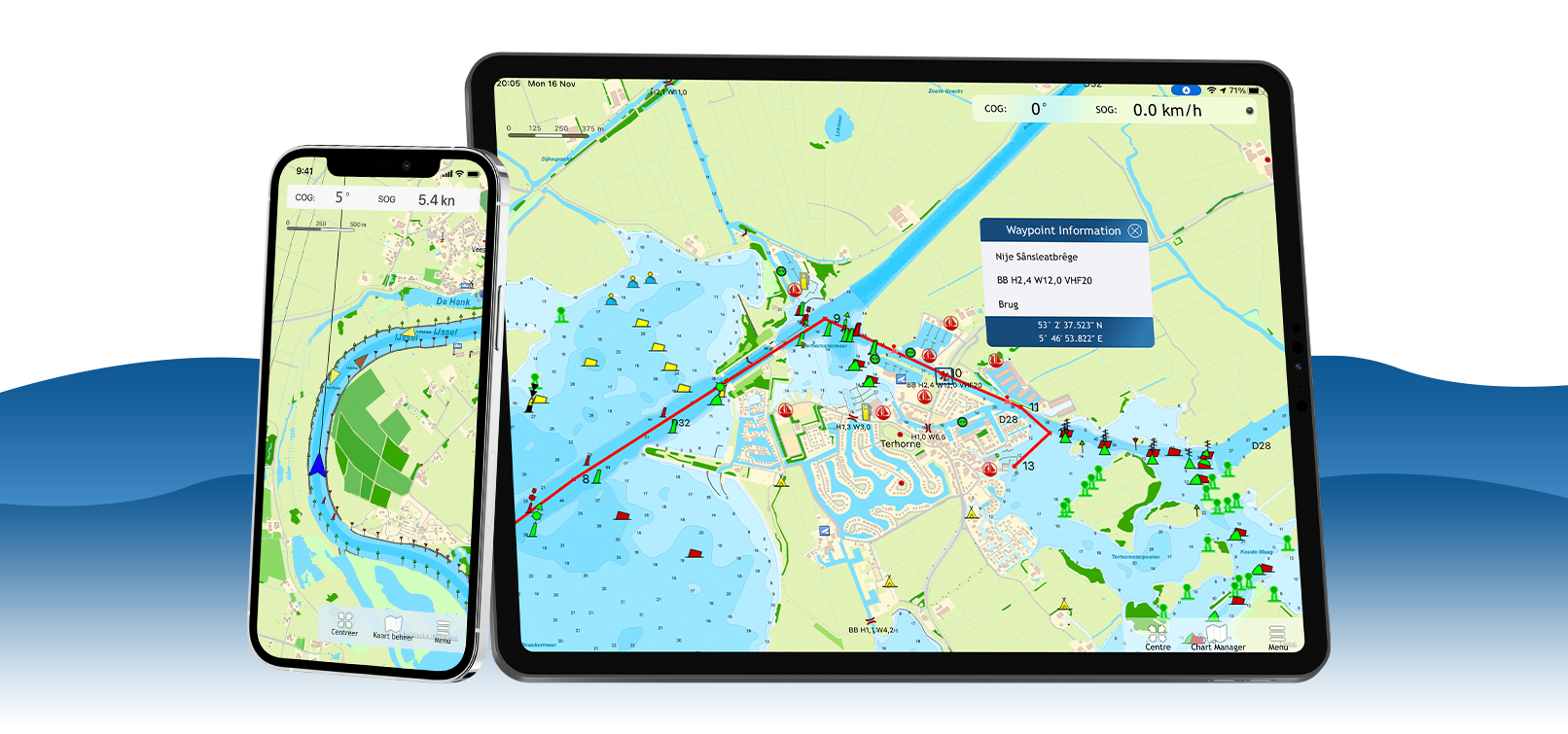
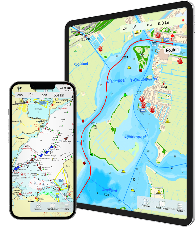
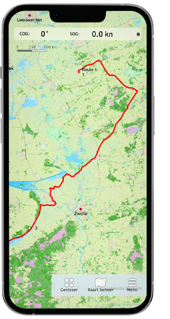
- WinGPS
- WinGPS series
- WinGPS versions
- WinGPS specifications
- For Windows
- WinGPS Lite
- WinGPS Navigator
- WinGPS Pro
- WinGPS Voyager
- For Android
- WinGPS Marine
- WinGPS Marine Plus
- WinGPS Smartwear
- For iOS
- Apps for iOS
- WinGPS Marine
- WinGPS Marine Plus
- DKW 1800 series
- Vaarkaart Friese Meren
- Service and upgrades
- Service Subscriptions
- WinGPS Yacht Navigator
- WinGPS trackpilot
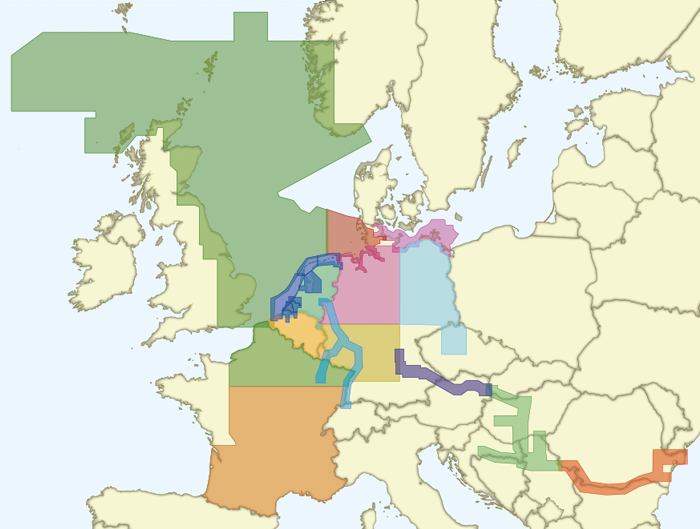
- Charts
- Chart overview
- DKW Inland waters
- DKW The Netherlands
- DKW Friese meren
- DKW Amsterdam
- DKW Biesbosch
- DKW Belgium
- DKW Northern France
- DKW Southern France
- DKW Northeast Germany
- DKW Northwest Germany
- DKW Southwest Germany
- DKW Rhine and Moselle
- DKW Danube 1-West
- DKW Danube 2-Central
- DKW Danube 3-East
- DKW Coastal waters
- DKW 1800 series
- DKW 1600+
- DKW UK1 English & Scottish Eastcoast
- DKW German Bight
- DKW German Baltic coast
- DKW Imray series
- DKW Delius Klasing series
- NV-Verlag series
- Exclusive for Android
- Subscription - DKW the Netherlands
- Chart apps
- Other
- Hardware
- Simulators
- Shop
- Downloads
- Support
- Downloads
- Help pages
- Documentation
- System Requirements
- Availability GRIB files
- Frequently asked questions - FAQ
- WinGPS 5
- WinGPS Marine (Android)
- WinGPS Marine (iOS)
- Installation help
- WinGPS 5 (Windows)
- WinGPS Marine (Android)
- Tips
- Offline installation DKW charts (Windows)
- Installation ENC charts (Windows)
- Connecting SD card (Android)
- NV Verlag charts
- Offline NOAA Charts
- Download TeamViewer
- Contact
- Contactform - Helpdesk
- Callback Service
- Commercial Shipping
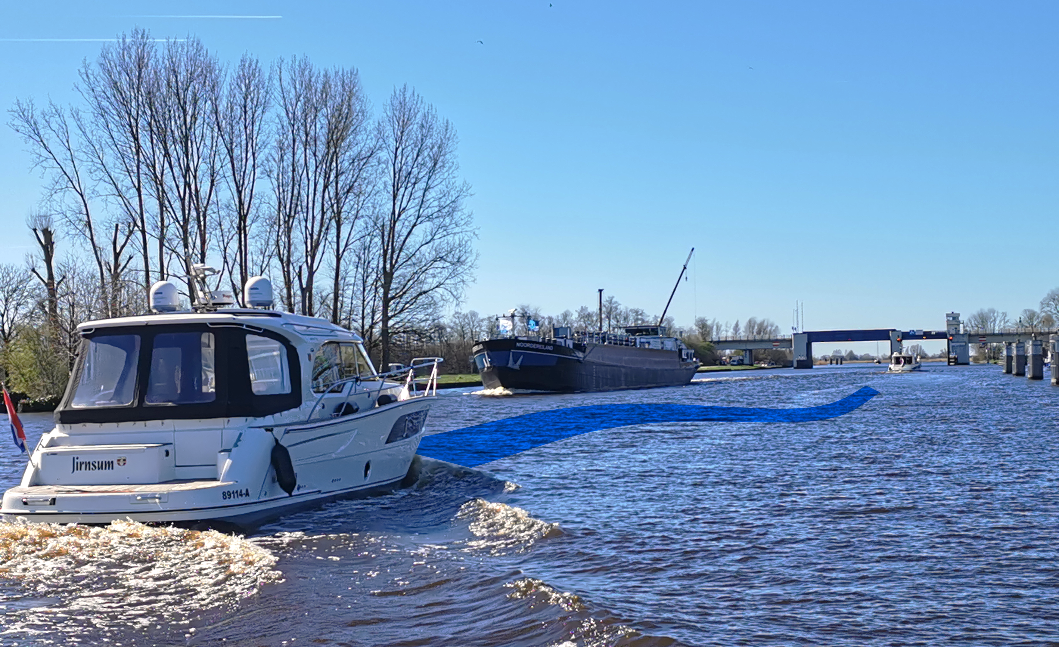
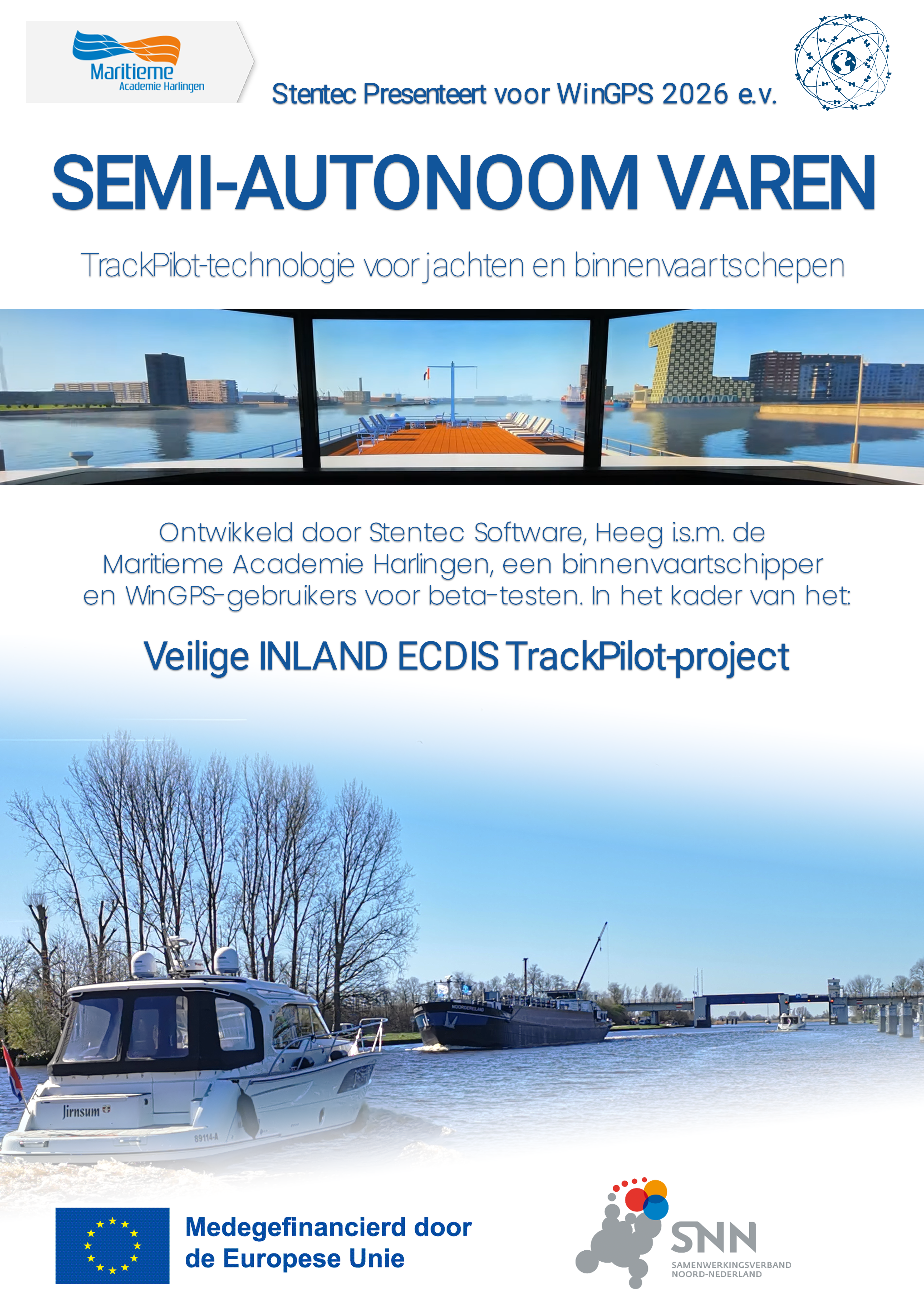
TrackPilot for WinGPS 6
Stentec presents SEMI-AUTONOMOUS NAVIGATION for WinGPS 2026 and later:
TrackPilot technology for yachts and inland waterway vessels
you can turn your existing autopilot (mounted on your tiller or steering wheel) into a smart trackpilot.
With a single push of a button, you automatically follow:
Ideal with DKW charts and IENC (via the Stentec IENC update server).
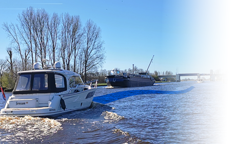
The TrackPilot has proven itself in commercial shipping for years. Now it’s available for sailing and motor yachts, as well as for small commercial vessels.
Fewer rudder movements mean smoother sailing, a quieter ride, and fuel savings.
Want to take control yourself? With the push of a button, the TrackPilot takes over again.
The result? Greater comfort and lower fuel consumption.
in collaboration with the Maritime Academy Harlingen, an inland waterway skipper, and WinGPS users for beta testing. As part of the:
Veilige INLAND ECDIS TrackPilot-project (Safe INLAND ECDIS TrackPilot project).
This 3-year EFRO-0148 project is co-financed by the European Union and the Dutch government. The project duration is from Q2 2025 through Q1 2028.
The aim of the project is to develop, test, and demonstrate an innovative, safe track pilot for inland waterway shipping, as well as a derivative version for recreational boating.
The intended results are a working and tested prototype of the TrackPilot, and a report with recommendations that can serve as a basis for new safety regulations. In addition, the project lays the groundwork for future research into autonomous navigation, and the knowledge gained will be incorporated into skipper training.
For the TrackPilot project, Stentec, in collaboration with the Maritime Academy Harlingen (MAH), is developing a smart autopilot for inland waterway shipping and recreational boating. The system automatically follows the route while taking the environment into account, such as bridges and other obstacles.
A key component is a self-learning ship model, also known as a Digital Twin. This is a digital copy of the ship that mimics its behavior and continuously learns. As a result, the system continues to operate reliably even if the GPS or compass fails.
The TrackPilot system is being tested step by step: first in WinGPS using a simulator, then on the MAH’s inland waterway simulator, and finally aboard real ships, including a commercial inland waterway vessel.
Stentec presents SEMI-AUTONOMOUS NAVIGATION for WinGPS 2026 and later:
TrackPilot technology for yachts and inland waterway vessels
you can turn your existing autopilot (mounted on your tiller or steering wheel) into a smart trackpilot.
With a single push of a button, you automatically follow:
- the extensive European route network or
the center of the waterway - a previously sailed route
- the route of another AIS vessel,
for example, a friend’s
Ideal with DKW charts and IENC (via the Stentec IENC update server).
The TrackPilot has proven itself in commercial shipping for years. Now it’s available for sailing and motor yachts, as well as for small commercial vessels.
Fewer rudder movements mean smoother sailing, a quieter ride, and fuel savings.
Want to take control yourself? With the push of a button, the TrackPilot takes over again.
The result? Greater comfort and lower fuel consumption.

![]()
in collaboration with the Maritime Academy Harlingen, an inland waterway skipper, and WinGPS users for beta testing. As part of the:
Veilige INLAND ECDIS TrackPilot-project (Safe INLAND ECDIS TrackPilot project).
This 3-year EFRO-0148 project is co-financed by the European Union and the Dutch government. The project duration is from Q2 2025 through Q1 2028.
The aim of the project is to develop, test, and demonstrate an innovative, safe track pilot for inland waterway shipping, as well as a derivative version for recreational boating.
The intended results are a working and tested prototype of the TrackPilot, and a report with recommendations that can serve as a basis for new safety regulations. In addition, the project lays the groundwork for future research into autonomous navigation, and the knowledge gained will be incorporated into skipper training.
For the TrackPilot project, Stentec, in collaboration with the Maritime Academy Harlingen (MAH), is developing a smart autopilot for inland waterway shipping and recreational boating. The system automatically follows the route while taking the environment into account, such as bridges and other obstacles.
A key component is a self-learning ship model, also known as a Digital Twin. This is a digital copy of the ship that mimics its behavior and continuously learns. As a result, the system continues to operate reliably even if the GPS or compass fails.
The TrackPilot system is being tested step by step: first in WinGPS using a simulator, then on the MAH’s inland waterway simulator, and finally aboard real ships, including a commercial inland waterway vessel.


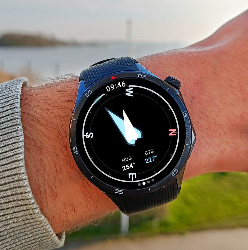
Navigate on your Wear OS smartwatch
with WinGPS Marine Plus for Android
Navigation data always at your fingertips, without picking up your phone. The new WinGPS Marine app for Wear OS displays live data from your navigation system directly on your wrist: course, speed, depth, wind data, route info, and more.
Customize the instrument panel yourself: choose which fields you see and in what order. The compass screen guides you with vibrations and an audible signal when you approach your desired course. Alarms from your navigation system appear directly on the watch, even when the app is running in the background.
The app works on Samsung Galaxy Watch, Google Pixel Watch, and other Wear OS watches, and connects via Bluetooth to WinGPS Marine Plus on your Android phone.
You can find a complete overview of the functionalities of WinGPS on your smartwatch, and installation tips, further down this page.
![]()
To use WinGPS on your smartwatch, you need our navigation app 'WinGPS Marine Plus' for Android.
With this navigation app you can see your position, create routes over open water and over the extensive route network (including bridges and locks information), download GRIB files for weather forecasts, view current and tide data on the Dutch coast, connect on-board instruments such as AIS, and more.
Ideal for all types of skippers: use WinGPS Marine Plus as a handy backup on your yacht, or as main navigation for day trips on a sloop, canoe or rental boat.
WinGPS Feature Overview on Smartwear
The WinGPS Marine Companion app for Wear OS displays live data from your navigation system directly on your smartwatch.
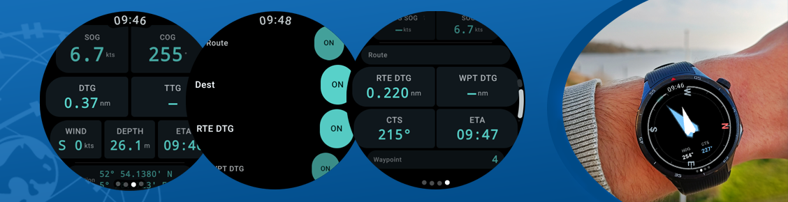
LIVE NAVIGATION TOOLS
The heart of the app: a fully configurable instrument panel on your wrist. You choose which data you see and in what order – drag them to your preference.
Available fields:
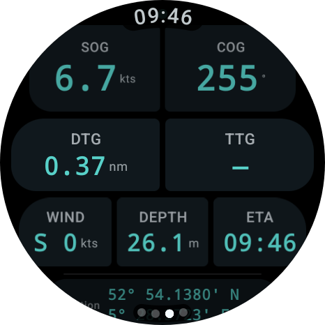
- COG - Course over Ground
- SOG - Speed over Ground
- STW - Speed through Water
- HDG - Compass Direction
- VMG - Speed Towards Waypoint
- TTG - Estimated Travel Time to Waypoint
- ETA - Estimated Arrival Time
- CTS - Course to Steer
- Depth - Water Depth Under the Keel
- Wind - Wind Speed and Direction (Real and Estimated)
- Position - Latitude and Longitude
COMPASS DISPLAY WITH HAPTIMIC GUIDANCE
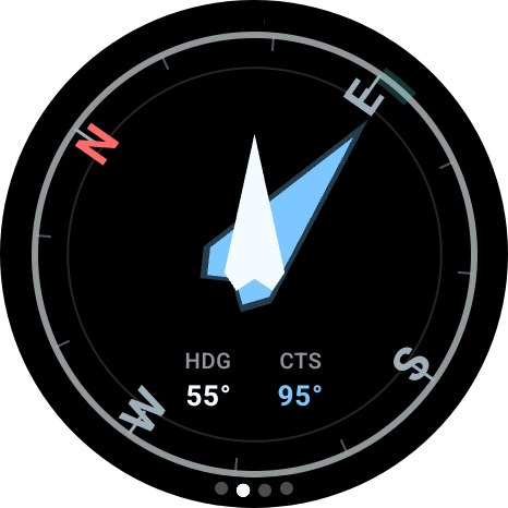
- Blue arrow points to the next waypoint
- White arrow shows the direction of your wristband
- Green arc marks the 10-degree "on course" zone
- Approach vibration: when you get close to the desired course,
the watch will vibrate to indicate that the course is correct - Audio signal at less than 3 degrees deviation
- Chart letters (N/E/S/W) rotate with the course - North always
points to geographic north
ROUTE INFORMATION
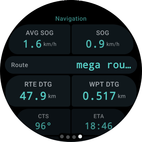
on one screen:
- Route name and destination
- Name of the next waypoint
- Distance to waypoint and total remaining route distance
- Average speed and VMG
- Course to sail and estimated arrival time
- XTE bar - when connected to Windows, a visual indicator that
shows whether you are deviating left or right from your route - Stop or change route directly from the watch
- List of recently used routes, instantly activated
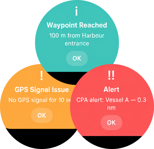
ALARM NOTIFICATIONS
When an alarm sounds on your navigation system, it appears immediately as a full-screen notification on your watch - even if the app is running in the background:
- Color coding by severity: red (critical),
orange (warning), blue (info) - Clear title and message description
- Notifications are tracked in the notification list, so
you don't miss anything
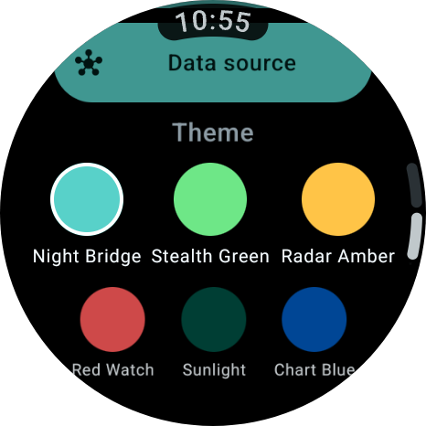
Choose the theme that suits the conditions:
- Night Bridge (standard, dark) - Night navigation, aqua accent
- Stealth Green (dark) - Night, minimal glare
- Radar Amber (dark) - Radar style, gold accent
- Red Watch (dark) - Night navigation, red accent
- Daylight (light) - Daytime, warm light
- Nautical Blue (light) - Daytime, nautical blue
ALWAYS-ON DISPLAY (AMBIENT MODE)
When you lower your wrist, the watch switches to a low-power display that protects your OLED screen:
- Compass screen shows only the course ring and CTS value
- Instrument screen shows only COG and SOG
- Navigation screen shows route name and current speed
- No animations, no unnecessary elements
CROWN CONTROL
All scrollable screens respond to the crown wheel or the rotating bezel of your watch, with haptic feedback at every step.
TWO DATA SOURCES
The app works with both the Android phone and directly with WinGPS on your Windows PC:
- Bluetooth - pair with the WinGPS Marine app on your phone
- Wi-Fi - connect directly to WinGPS on your onboard PC via UDP (in early development)
ALWAYS VISIBLE WHILE SAILING
As long as WinGPS Marine is active, a shortcut appears at the bottom of your watch face. One tap and you are back in the app, without having to search.
WinGPS Installation Tips on Smartwear
This is the fastest way to get started:
1. Open the Play Store on your phone
2. Search for "WinGPS Marine"
3. Open the app page
You will now see one of the following situations:
Situation A - Everything is in order:
Below or next to the installation button, you will see a second option such as "Install on [name of your watch]". Go directly to step 2.
Situation B - Only phone installation button visible:
Your watch is not recognized. Go to the "Having trouble?" section at the bottom of this manual.
Situation C - "Not available for your devices":
Your watch is not supported. Check the list under "Does NOT work on" at the top of this manual.
STEP 2 - INSTALL THE APP ON YOUR WATCH
1. Open the Play Store on your phone
2. Search for "WinGPS Marine" and open the app page
3. Tap "Install on [name of your watch]"
4. The installation starts automatically on your watch - you do not need to do anything else on the watch itself
5. Wait 1 to 2 minutes. Make sure your watch stays near your phone and that Bluetooth is turned on.
You can also start the installation via the Play Store on the watch itself:
1. Press the button on the side of your watch to open the menu
2. Scroll down to Play Store
3. Search for "WinGPS Marine"
4. Tap Install
STEP 3 - OPEN THE APP ON YOUR WATCH
1. Press the button on the side of your watch to open the app overview
2. Scroll through the list and look for WinGPS Marine
3. Tap on it to open the app
4. Start WinGPS Marine on your phone (or tablet)
5. As soon as the phone app is active and receiving navigation data, it will automatically appear on your watch
------
DID THIS STEPS NOT WORK?
The app is not in the list on my watch
Please wait a moment - apps can sometimes take 5 minutes to install. Ensure your watch:
- Is charged (at least 20% battery)
- Is connected to your phone (Bluetooth on)
- Is connected to Wi-Fi or stays near the phone
1. Turn Bluetooth off and on again on your phone
2. Restart your watch (press and hold the side button > "Restart")
3. Try the installation again via step 2
My watch is not recognized in the Play Store
The most common causes:
1. Watch is not paired with your phone
Your watch must be connected to your phone via a companion app. Which app you need depends on your watch brand:
Samsung Galaxy Watch -> Galaxy Wearable
Google Pixel Watch -> Pixel Watch
OnePlus Watch -> OHealth
Oppo Watch -> OHealth
Xiaomi Watch -> Xiaomi Wearable
Mobvoi TicWatch -> Mobvoi Health
Fossil Gen 6 -> Fossil Smartwatches
TAG Heuer Connected E4 -> E3/E4 TAG Heuer Connected
Montblanc Summit 3 -> Montblanc Summit
Hublot Big Bang e Gen 3 -> Hublot Big Bang e Gen3
Search for the corresponding app in the Play Store, install it if you haven't already, and follow the on-screen pairing guide.
2. Phone and watch use different Google accounts
Phone and watch must be logged in with the exact same Google account (Gmail address).
Check the account on your phone:
1. Open the Play Store on your phone
2. Tap your profile picture or initials in the top right corner
3. At the top, you will see the email address you are logged in with - remember this
Check the account on your watch:
1. Open the Play Store on your watch
2. Scroll all the way down
3. Tap Accounts
4. Check if the same email address is listed here
Are there different email addresses listed? Then you need to link a new account on the watch. You do this via your watch's settings: go to Settings > Other > Google > Accounts. The exact naming may vary slightly depending on the watch brand, but the Google button is almost always located under "Other".
3. Watch is not visible in the Play Store
1. Open the Play Store on your phone
2. Tap your profile picture or initials in the top right
3. Tap "Manage apps and devices"
4. Tap the "Manage" tab at the top
5. Tap "Devices" in the top right
6. Is your watch in the list and does it say "Active"? Then everything is fine - try step 1 again.
7. Is your watch not listed or does it say "Inactive"? Then make sure your watch is turned on, is near your phone, and that Bluetooth is turned on on your phone. Then try again.
QUESTIONS OR PROBLEMS?
Send an email to helpdesk@stentec.com containing:
- The brand and model of your watch
- The Android version of your phone (found via Settings > About phone)
- A description of what is going wrong
|
|
Digital charts Delius Klasing
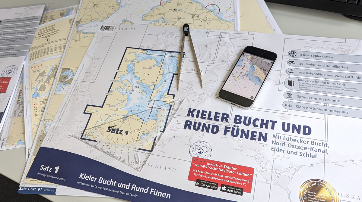
Congratulations on purchasing your Delius Klasing chart!
By purchasing this chart you will receive free access to the digital version of the chart and the navigation program WinGPS Yacht Navigator for one year.
To take advantage of this offer, you must link the license number to your Stentec account. Below you will find more information about how you can achieve this.
Klicken Sie hier für Deutsch. Klik hier voor Nederlands.How do I install the chart and WinGPS Yacht Navigator?
When you purchase a paper chart from Delius Klasing you will receive a license code. This license code is located on the paper chart and entitles you to one year of free access to the digital version of the chart .
In addition, you will receive a one-time free one-year access to the navigation program WinGPS Yacht Navigator (worth €29.90). This program has been specially developed for the Delius Klasing charts and is available for Windows, Android and iOS.
Follow the steps below to install the chart and WinGPS Yacht Navigator:
1. Link your obtained license number to your Stentec account.
Please note: paper charts marked 'edition 2023/2024' may contain an old license code. You cannot enter this code here. You can recognize this by the mention of 'Yacht Navigator' instead of 'WinGPS Yacht Navigator' on the form. Contact Delius Klasing for a new code.
If you do not have an account yet, you can create one directly here.
2. Download WinGPS Yacht Navigator by clicking on the download button of the relevant platform.


3. Open WinGPS Yacht Navigator and log in with your Stentec account.
5. Download the chart in WinGPS Yacht Navigator:
- WinGPS Yacht Navigator for Windows:
after you have opened WinGPS, you will be presented with the News Center. Here you will see a notice that a recently purchased chart has not yet been installed. Click 'Update All' and you will see a screen with all your charts available for download/update, including the chart you just linked. Check the box of this chart and click 'Continue'. - WinGPS Yacht Navigator for Android:
go to 'Chart manager' in the menu. Now swipe right so you go one screen to the left. Here are all your downloadable charts, including the chart you just linked. Click on the chart you would like to download, and press 'Download' in the upper right corner. - WinGPS Yacht Navigator for iOS:
go to 'Download Manager' in the menu. Here you will see all your charts available for download, including the chart you just linked. Click on the download button to the right of the chart in Download Manager.
Partnership Stentec and Delius Klasing
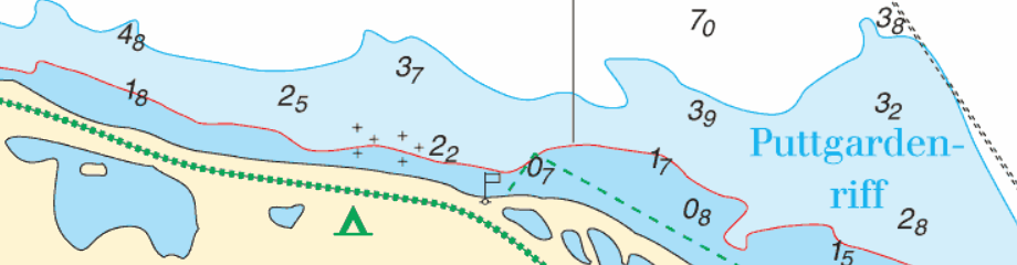
Since 2014, Stentec Software has been publishing the well-known Delius Klasing charts digitally. These are based on the paper charts of Delius Klasing and have a clear and orderly chart image.
Now, 10 years later in 2024, our collaboration has been strengthened and the digital versions of Delius Klasing's paper charts can be downloaded exclusively via Stentec..
These digital charts, also called DKW charts, are compatible with all versions of WinGPS. In honor of this wonderful collaboration, we have developed a special WinGPS version for the Delius Klasing charts: WinGPS Yacht Navigator.
The map image of the digital charts from Delius Klasing continues to retain the familiar clear appearance. For more information about the digital charts, click more information below.
System requirements:
- Valid version of WinGPS
- Between 40MB and 300MB disk space (varies per chart set)
- Windows laptop or PC: Windows Vista, 7, 8, 10 or 11 with DirectX 9 graphics card (or higher)
- Android tablet or smartphone: Android operating system, at least 2 GB of RAM (RAM)
- iPad or iPhone: iOS 12 (or higher), click here for more information.
Delius Klasing charts
Below you will see an overview of all charts from Delius Klasing that come with a license code for a digital chart.
|
|
Order your paper charts from Delius Klasing now and receive 1 year of free access to the digital version of the chart and a one-time 1 year of free access to the WinGPS Yacht Navigator navigation program.
These digital charts are also available separately as an annual subscription, without paper charts.
Want to expand your digital chart package?
Did you know that Stentec also supplies digital charts of other areas, such as the popular DKW Vaarkaart Nederland or DKW 1800 series? These charts are very detailed and are updated regularly. Ideal for the busy and changeable Dutch waters.
Cancel your subscription?
You can easily cancel your subscription by filling out the form below:

Discover the benefits of our Premium and Service Subscriptions 2026!
With a Premium Subscription, you are guaranteed to have the latest WinGPS navigation software for Windows, extensive support, and exclusive benefits such as discounts on charts and convenient updates.See below for the difference between a single WinGPS upgrade and the Premium Subscription.
Don’t have WinGPS for Windows, but still want to benefit from the extra service and discounts? Then choose the Service Subscription.


* This discount only applies to the 100% Stentec DKW chart sets.
Look at the bottom of this page for more information.
WinGPS 6 - 2026 edition
In the new edition of WinGPS 6, the route planner has been further improved. In addition, work is underway on the first test versions with TrackPilot, and a new bridge collision alarm is being introduced.
More information about the new features we developed for WinGPS 6 – 2025 can be found here:

Curious about the innovations in WinGPS 6 in recent years? Click here..


Automatic renewal
Many of our users have indicated that they would like to use the option to automatically renew their subscription annually. We are pleased to announce that this is now possible!
Choose Premium Subscription - continuous in our online shop.
You can find more information about automatic renewal in our online shop under Premium Subscription.
If you do not select 'automatic renewal', your subscription will be valid from the moment of purchase until 31 December 2026. After this date, you will no longer be entitled to the benefits mentioned above.
In the autumn of 2026, you will receive a message from us on how the subscription can be renewed and the benefits will continue in 2026.
WinGPS Lite or WinGPS Marine
If you do not have WinGPS 5 or 6 Navigator, Pro or Voyager, but you navigate with WinGPS 5 or 6 Lite or WinGPS Marine (Android or iOS), then the new Service Subscription is interesting for you. This includes not only the installation service, but also support if you have questions about the use of WinGPS.


Our service in 2026
With a Premium or Service Subscription, you can rely on our support with complete peace of mind and get the most out of your WinGPS navigation.
The service rate in 2026 remains €20 per quarter hour. If you have a Premium or Service Subscription, these costs are waived, allowing you to enjoy unlimited helpdesk support throughout the year for the price of just one hour of service.
Subscribers also benefit from a callback service, so you don’t have to wait on hold during busy periods. Simply leave your details, and we’ll call you back as soon as possible.
You can also contact us via WhatsApp, send a photo of your question or issue, and often get assistance even faster, so you can continue navigating with confidence. 
Discount on DKW chart sets
By subscribing to the Service or Premium Subscription, you will receive a €20 discount on new 100% Stentec DKW chart sets and a €10 discount on upgrades to the 100% Stentec DKW chart sets.
View the overview below on which charts this discount can be applied to.
Frequently Asked Questions - FAQ
What happens if I don’t upgrade my WinGPS (for Windows) to the latest edition?
Your license will remain active, but you will no longer receive updates. You can continue using WinGPS, but for your safety we recommend keeping the program up to date. This ensures that you continue to receive updates to the waterway network, bridges and locks, and, for Pro, Voyager, and Inland, also the latest Dutch tide data. In addition, you will benefit from program improvements and any new features.
How can I update my WinGPS Marine app for Android or iOS?
You don't need a Premium Subscription to update our WinGPS Marine apps.
For WinGPS Marine Plus for iOS, the following applies: you purchase the app once, after which you automatically receive all available updates, both for the app itself and for the waterway network.
WinGPS Marine Plus for Android is available as an annual subscription, which renews automatically. As long as this subscription is active, you will receive all available updates for the app, the waterway network, and NL-tidal data. Once you cancel your subscription, your app will revert to the free Lite version.
You can, however, opt for the Service Subscription. This subscription still provides you with exclusive discounts and premium helpdesk service.
How can I download the IENC charts for the Netherlands in WinGPS?
With a Premium Subscription, you receive free access to the IENC Update Service Netherlands.
In WinGPS, go to:File → Properties → IENC Area and check “Netherlands.” These charts will now be downloaded and updated automatically whenever new data becomes available from the relevant authorities (an internet connection is required).
Via Charts → Chart Manager, you can select which charts you wish to display in WinGPS.
The IENC Update Service NL can also be purchased separately or expanded to include additional countries. Click here to view the different IENC Update Services.
How do I get a discount on the DKW charts?
If you have a Premium or Service Subscription, you will receive a discount on 100% Stentec DKW charts*.
Once you have purchased such a subscription, it will be linked to your account and the discount will automatically be applied to your chart orders. We recommend purchasing your Premium or Service Subscription first, and only placing your chart order once the subscription has been processed.
How can I purchase a subscription?
You can order a Premium or Service Subscription directly through our online shop.
Need help? Feel free to contact us. We’ll be happy to assist you and can also complete your order by phone or email if you prefer.
How can I cancel a subscription?
You can cancel an ongoing subscription by calling +31 (0)515 443515 or by sending an email to stentec@stentec.com.
Get to know our on-board navigation programs!


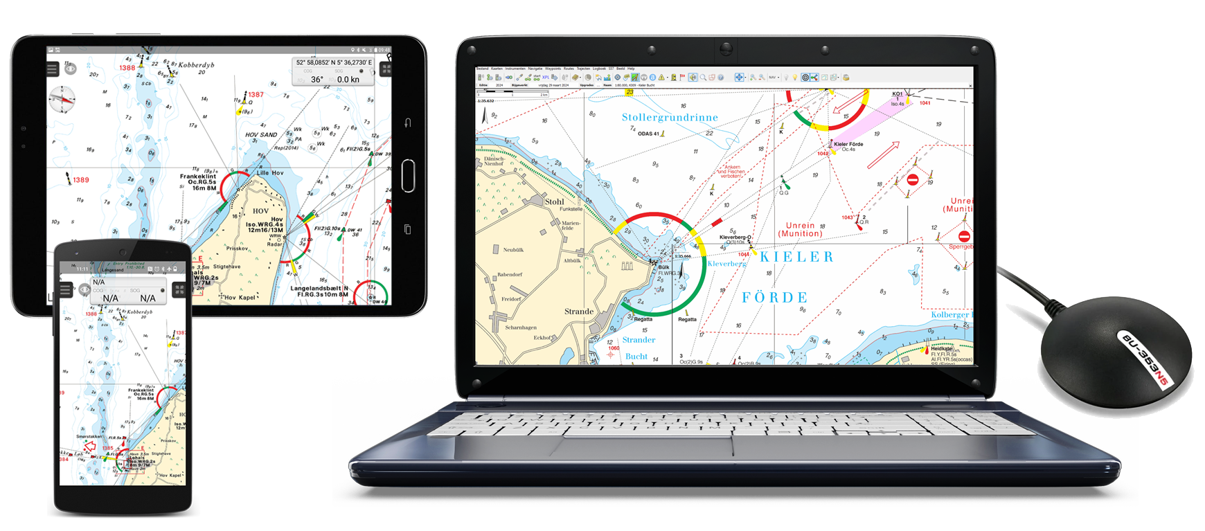
| Complete your navigation package with charts and a GPS Choose the WinGPS version that suits your situation on board, or use several WinGPS versions side by side. To complete the navigation package you also need a GPS receiver and the maps of your sailing area. This can be, for example, our own DKW charts. You can use this on all 3 systems at the same time! Example situation: Plan the routes at home on a PC with a large screen, take these routes with you on a laptop on board and also use the charts on your iPhone and an Android tablet so that you always have a backup system at hand. The charts can be installed on 3 systems of Windows and Android. You also have 1 installation left for your iPhone or iPad. |
Hardware For positioning on your laptop or PC it is ideal to use a USB GPS receiver. Most smartphones, tablets and iPhones already have an internal GPS receiver that you can use to determine your position in WinGPS. Note that not all iPads have an internal GPS receiver. A wireless Bluetooth GPS receiver is then ideal for determining your position. |
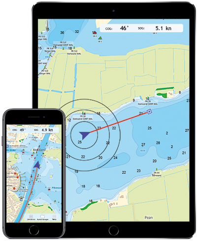
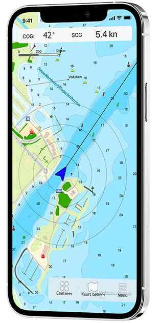
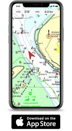
Navigate on your iPad and iPhone
Since 2019, the navigation program WinGPS is also available in the Appstore. In addition to WinGPS 5 on the laptop and WinGPS Marine on an Android device, you can also navigate on an iOS device!
On this page we would like to tell you more about our various navigation apps for your iPad and iPhone. At the bottom of the page we will keep you informed of the latest developments. Onderaan de pagina zullen wij u op de hoogte houden van de laatste ontwikkelingen hierin.
WinGPS Marine for iOS
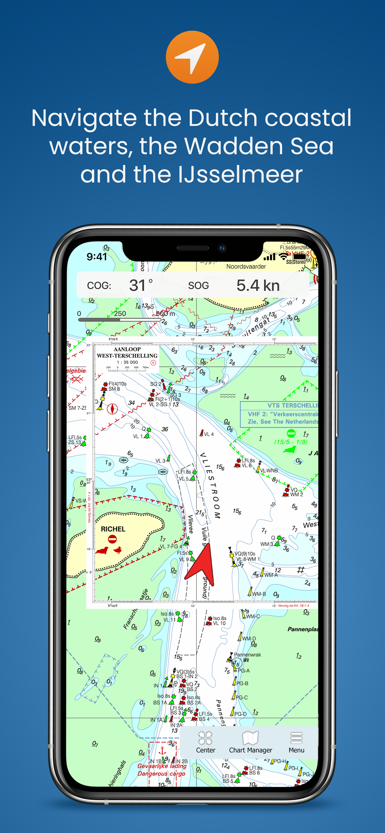
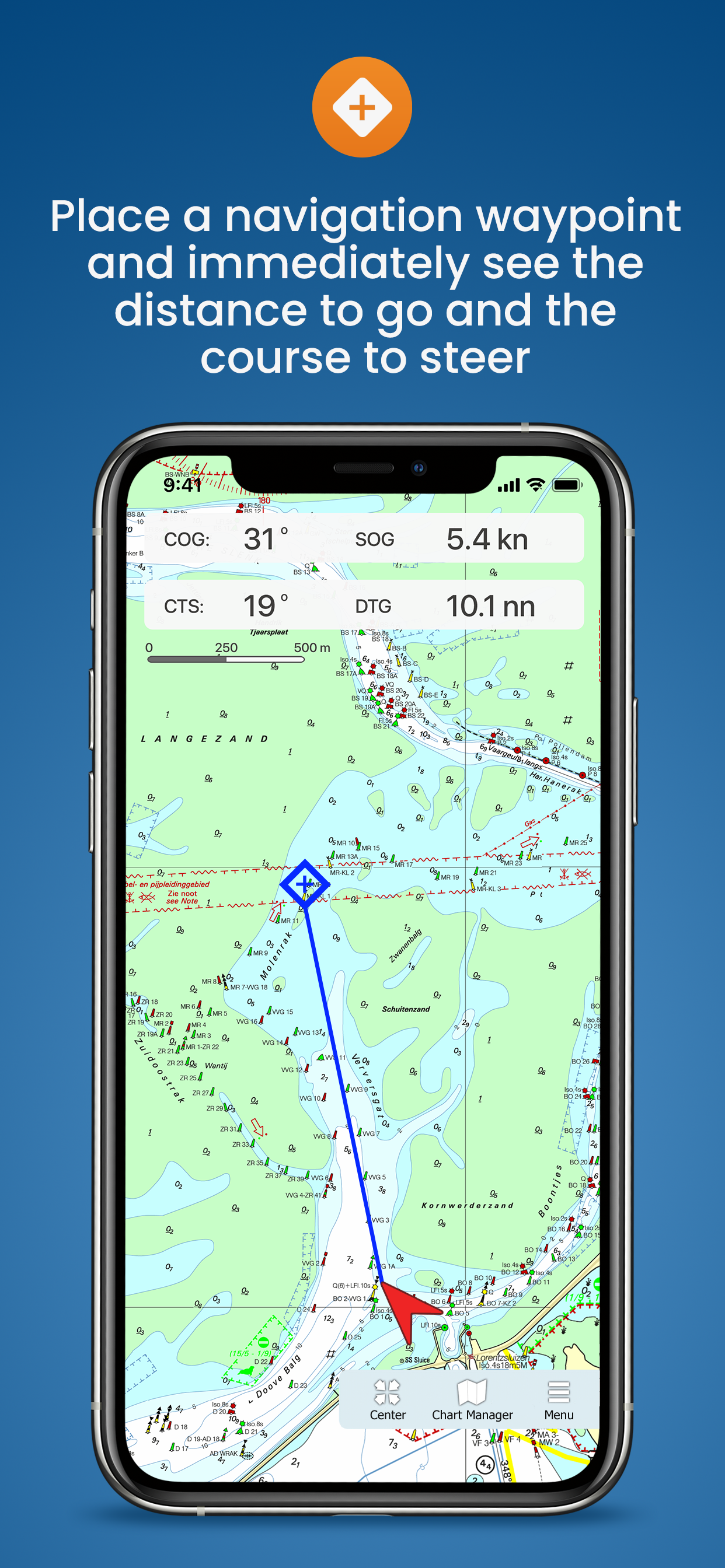
Get to know the navigation app WinGPS Marine for free and view your navigation charts, position and speed, among other things. Plot a navigation waypoint so that you immediately see the course-to-steer and distance-to-go. Ideal for smaller trips or as a backup.
If you choose the more extensive WinGPS Marine Plus app, you can plan routes, download GRIB-files and connect your AIS. Over time, this app will be expanded with functions such as current and tide data and connecting other on-board instruments. In this way you can create a complete back-up navigation system on board.
|

|
|
|
|---|---|---|---|
| GPS position, speed, course and distance over ground | |
|
|
| Tracks | |||
| Distance Circles | |||
| Navigation waypoint | |||
| Waterway network | |||
| Routes | |||
| Connect AIS | |||
| Course-up mode | |||
| GRIB-files from NOAA | |||
* Saving as well |
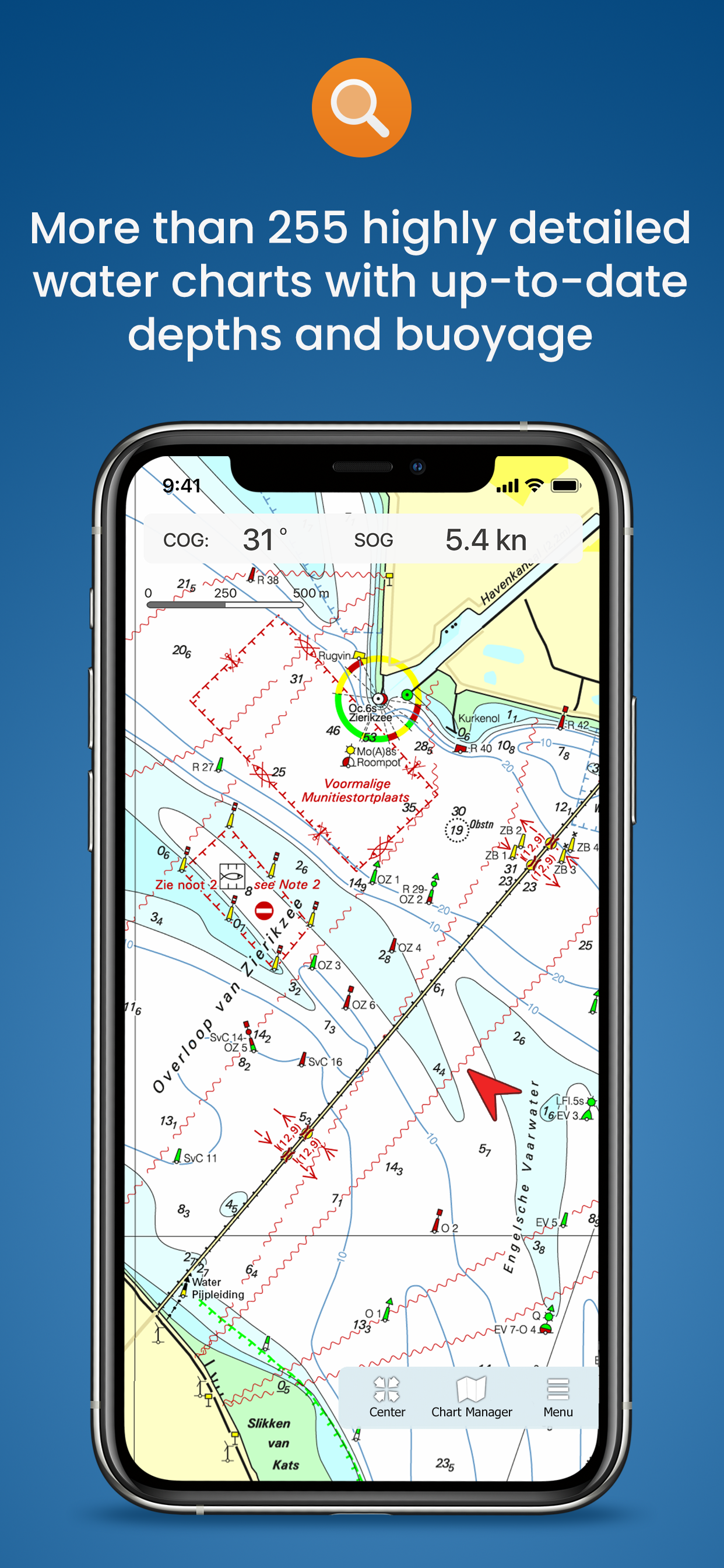
Charts in WinGPS Marine
The charts you can use in these apps are Stentec's own DKW charts. For example, the well-known DKW 1800 series including weekly update service or the free DKW Vaarkaart Frisian Lakes.
In WinGPS Marine you can also use Apple's free online charts for orientation. You can download the DKW charts directly in the app and use them for navigation, after you have logged in with your Stentec account.
| Note: Only 2018 and newer charts can be used in this app. Do you have older charts? Upgrade your charts in our online shop. Click here to upgrade your charts. |
 The Vaarkaart Friese Meren is a digital water charts of a large part of Friesland. This water chart can be used for free on your iPhone and iPad. |
 |
 | Bluetooth GPS Receiver If your iPad does not have an option for mobile internet, it also does not have an internal GPS receiver. If you want to use this iPad for navigation on board, an external GPS receiver is necessary to determine your position. |
Latest developments
|
GRIB-files from NOAA in WinGPS Marine Plus Posted on August 3, 2023
WinGPS Marine Plus
In WinGPS Marine you can now place a navigation waypoint on the waterway network, after which a route will automatically be drawn over the intervening waterways. 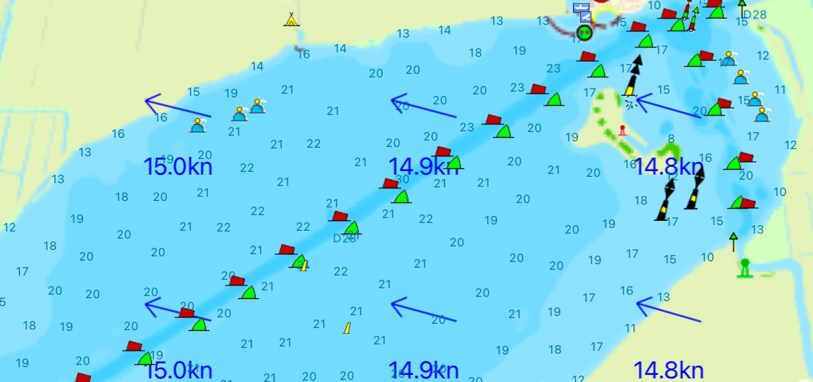
|
Routes over the waterway network in Marine Plus Posted on June 27, 2022
WinGPS Marine Plus
In WinGPS Marine Plus you can now plan a route over the waterway network, taking into account the dimensions of your ship, the waterways and the bridges & locks. 
|
|
Navigation waypoint on waterway network in WinGPS Marine Posted on June 27, 2022
WinGPS Marine
In WinGPS Marine you can now place a navigation waypoint on the waterway network, after which a route is automatically drawn over the intermediate waterways. 
|
Waterway network in WinGPS Marine and Marine Plus Posted on august 9, 2021
WinGPS Marine and Marine Plus
The WinGPS Marine and WinGPS Marine Plus apps now also include the waterway network with information about waterways, bridges and locks. 
|
Posted on December 17, 2020
WinGPS Marine Plus
Download the more extensive navigation app WinGPS Marine Plus in the Appstore from now on! You can already plot routes, connect your AIS to it and switch on the Course-up mode. Over time, more functions are added, such as GRIB files and linking other on-board instruments. 
|
Update WinGPS Marine Posted on Ocotober 25, 2019
WinGPS Marine
From now on you can also view your sailed routes, turn on distance circles and place a navigation waypoint in WinGPS Marine. 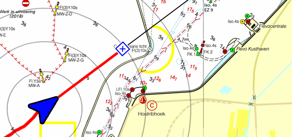
|
| | |
|
Release WinGPS Marine Posted on June 11, 2019
WinGPS Marine
Download the free navigation app WinGPS Marine now in the Appstore! Now you can load all your DKW charts and view your position, course and speed. More features will be added in upcoming updates. 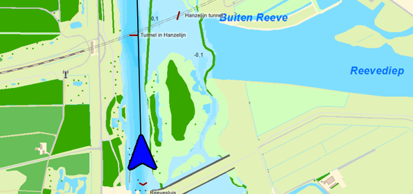
|
Bèta WinGPS Marine Posted on March 15, 2019
WinGPS Marine
The beta version is online and is being tested by WinGPS users. The feedback from this is used to be able to release a solid version of WinGPS Marine in the short term. 
|
|
€29,90 (incl. VAT). |

WinGPS Yacht Navigator
Specifically for our collaboration with Delius Klasing, we have developed this unique WinGPS version: WinGPS Yacht Navigator.
WWhen you purchase a paper chart from Delius Klasing, you receive the corresponding digital chart and one year of WinGPS Yacht Navigator free of charge.
With a single license, you can use WinGPS Yacht Navigator on Windows, Android and iOS.
Read more below about the functionalities of WinGPS Yacht Navigator, among other things.
WinGPS Yacht Navigator Versions
Get to know the WinGPS Yacht Navigator navigation program. This version of WinGPS can be used with a single license on all three platforms: Android, iOS, and Windows. This ensures you always have your navigation at hand and a backup of your navigation on board.
Upon initial installation of WinGPS Yacht Navigator, you receive the free version. This offers limited functionalities, but allows you to view your position and see the chart.
With the paid version, you can plot routes, place waypoints, and more. See the table below for an overview of all functionalities.

|

|

|
|
|
|---|---|---|---|---|
| GPS position, speed, course | |
|
|
|
| Tracks | ||||
| Distance measurement | ||||
| Waypoints | ||||
| Waterway network | ||||
| Routes |
Download your WinGPS now
You can obtain a WinGPS Yacht Navigator license by purchasing it in our online shop,
or because you received it with the purchase of a paper chart from Delius Klasing.
Did you receive this with a paper chart from Delius Klasing?
Here you will find more info on how to activate and download it to your devices:
Do you want to renew your WinGPS Yacht Navigator?
Then go to our online shop and order for €29.90 per year:
Do you want more functionalities than WinGPS Yacht Navigator offers?
Then take a look at our other WinGPS versions:
|
Vaarkaart Friese Meren Available for free for iPad and iPhone. |
|
|

 |
Vaarkaart Friese Meren for iOS This chart is perfect when you are planning a trip on the Frisian Lakes. Great while renting a boat, but also for skippers and crew of sailing boats, motorboats and sloops on the Frisian Lakes. Even while using a canoe or kayak or planning a fishing trip on the lakes this chart offers a clear image of your position of the beautiful Frisian landscape. The area this chart covers is from Stavoren, Makkum, Grou to Lemmer. Navigate on the Heegermeer, Fluessen, Morra, Oudegaster Brekken, Zwarte Brekken and Witte Brekken, Sneekermeer, Koevordermeer, Tjeukemeer, Langweerderwielen, Pikmeer/Wijde Ee and the many ditches, canals and pools. Depth image Processed within this chart is a unique, clear depth image received from the Friese Meren Project with beautiful colored depth levels and numbers along the water ways. Developed by Stentec in collaboration with Provincie Fryslân with the most recent depth measurements. This is a detailed chart with a scale of 1m/pixel, comparable with 1:3.000 on screen. The database accompanied with the chart has 3.393 waypoints and offers all kinds of useful water sports information. For example harbours, buoys, docks, water sport campsites and gas stations. |
Popular sailing chart for the Frisian Lakes
The DKW Vaarkaart Friese Meren has been available for Android and Windows since 2014 and has already been used by more than 60,000 water sports enthusiasts. More information about the Vaarkaart Friese Meren can be found at www.vaarkaartfriesemeren.nl
System requirements
Check via the link below if your device is suitable for this chart app. This app has the same system requirements as WinGPS Marine for iOS. In addition, you should take into account the size of the DKW Frisian Lakes charts. Check our online shop for the current size of these charts. |
Note: not every iPad has a built-in GPS receiver. If your device does not have an internal GPS receiver, you can use a bluetooth GPS receiver |
|
DKW 1800 series for iOS! Up to date all year round. |
|
 |
Charts
After purchasing the app you can immediately download all DKW 1800 charts and start using the app for navigation on board. The charts are linked to your Stentec account and can therefore also be used with WinGPS for Windows and WinGPS Marine for Android.
| Note: the updates for the DKW 1800 charts will be released weekly. Do you have the edition of last year? Then you can upgrade to the new edition for a special upgrade price in our online shop, which will also provide you with weekly BaZ updates for the charts. |
System requirements:
Check via the link below if your device is suitable for this chart app. This app has the same system requirements as WinGPS Marine for iOS. In addition, you should take into account the size of the DKW 1800 series charts. Check our online shop for the current size of these charts.
|
Note: not every device mentioned above has a built-in GPS receiver. If your device does not have an internal GPS receiver, you can use a bluetooth GPS receiver |
WinGPS Marine
Do you also want to sail outside the 1800 series area? Then we recommend WinGPS Marine: the free navigation app for iOS. Here you can also load other DKW charts and use them for navigation. WinGPS Marine can be upgraded, after which you can also set routes, download GRIB files for weather forecasts and link AIS.
| |
WinGPS Marine PLUS Navigate on your iPad and iPhone. |
|
|
|
WinGPS Marine Plus for iOS After the free app WinGPS Marine for iOS, Stentec releases the extended version WinGPS Marine Plus. This app included premium features and is developed for the iPhone and iPad. NEW - Plot a route with single points on open water, or plan the route over the waterway network taking into account the bridges, locks and restrictions of the waterways, and the dimensions of your ship. Navigate the waypoints using the course line, Course to Steer and Distance to Go and view and save your route. For inland waterways you can put the app in course-up mode. Expected soon Now that the route planning has been expanded by combining it with the waterway network, this will be optimized in the coming period. After this, we will add GRIB file downloads to WinGPS Marine Plus, for example to show wind and precipitation on the chart. The current and tide information is also planned for the development of WinGPS Marine Plus. |


Charts
The charts that can be used in this app, are Stentec’s own DKW-charts. For example the free chart DKW Frisian Lakes or the well-known DKW 1800-series for the Dutch coastal waters, including weekly update services.
At the first start-up of the app, you will be asked to log in with your account. The free default online maps from Apple are available in the app for orientation. The DKW-charts, which are connected to your account, can be downloaded directly in this app and be used for navigation.
| Note: only charts from 2018 and newer can be used in this app. Do you have older charts? Then you can renew them in our online shop. Click here to renew your cards > |
|
System requirements: |
| Note: not every ipad has a built-in GPS receiver. If your device does not have an internal GPS receiver, you can use a Bluetooth GPS receiver |
Let us know what you think
In the coming period, the app will of course be further upgraded, optimized and new (possibly paid) features will be added, for example GRIB files, stream and tidal information and the option to connect other board instruments. We would like to continue to receive your feedback about the current version and any wishes for future versions via the feedback form.
Do you have any questions?
Call us on +31 515 443515, fill in the contact form or make an appointment at our store in Heeg.
Click here for our opening hours.


News
 The boating season is in full swing, and the water is calling! Whether you’re planning a relaxing weekend getaway or a major trip on Europe’s inland...
 The new charts for the Wadden Sea, DKW 1811 and DKW 1812, and DKW 1805 (Oosterschelde, Veerse Meer, and Grevelingenmeer) are now available! The quarterly...
 Are you familiar with our WinGPS Marine Plus for Android? This popular navigation app is now available as an affordable subscription and can be paired with an...
| WinGPS Navigator |
|
• Easy to use route planner |

| WinGPS Marine |
|
A navigation app for use aboard your ship. An upgradable navigation solution for all sailors, from beginner to professional. |

Stentec Navigation is specialised in digital navigation for water sporters and commercial shipping.
Trackpilot-project : 2025-2028
|
Sail Simulator 5
|
|
|
TrackPilot for WinGPS 6Stentec presents for WinGPS 2026 and later |
|


Harinxmastrjitte 29
8621 BJ HEEG
The Netherlands
T +31 (0) 515 443515

Copyright © Stentec Software. All rights reserved.
By using this website you acknowledge that you agree with our user agreement.