WinGPS Inland Navigation Specially for inland navigation skippers Stentec has released the navigation program WinGPS Inland. This software can be used on your laptop or on-board PC. By loading the free iENC charts and connecting AIS and GPS, you can easily and quickly create an inexpensive navigation system on board. For whom The new navigation program WinGPS Inland was initially developed for commercial navigation on European inland waterways. By loading the free iENC it is possible to comply with the Information Mode, which has recently become mandatory on German inland waterways.
|
Free iENC The well-known S57 charts of European inland waterways that are made available free of charge by the various European governments, also known as iENC, can be used for navigation in WinGPS Inland. With this, you immediately comply with the Inland-ENC Information Mode, the new German law which makes it mandatory to use iENC on German highways (defined by the WSV). Create a chart image according to your wishes, using the S57 settings in WinGPS Inland. For example, you can combine DKW charts with the iENC for a more beautiful and quiet chart image. |
 |
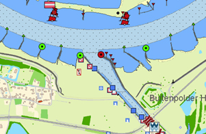
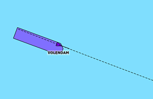
Combine ENC with DKW Since 1999, Stentec has been issuing its own charts, under the name DKW. Examples of this are the DKW 1800 series for Dutch coastal waters including a weekly update service, and the clear and detailed DKW Inland charts for European inland waterways. The DKW Inland charts are generally more up-to-date than the iENC. It is therefore ideal to combine these DKW charts with the iENC, so that you always have the most up-to-date charts on board. It can also offer you a more clear chart image. The underlying chart is displayed by turning off the iENC's land features. In the image on the right you see the DKW The Netherlands on the land and on the water you see the iENC. The buoyage and other navigation information is plotted on the chart as waypoints that you can switch on or off per group. For example, you can choose to use the buoyage of the DKW charts or the iENC. |
 |
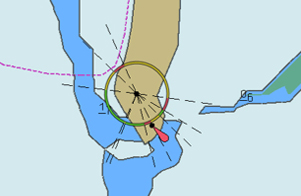
AIS and GPS By connecting your AIS equipment and GPS receiver to the laptop or on-board PC you will always see the position, speed and course of your own ship and of the other AIS ships. WinGPS Inland has no limit to AIS objects that can be displayed, so you will no longer miss a ship. In busy areas you can of course choose to apply certain filters, in order to get the ships more relevant to you more clearly visible on the chart. Turn on the AIS extrapolation and the AIS objects will be displayed smoothly on the chart. With this, an expected position is drawn on the chart, relative to the last position, speed and course received. You can also show the scaled outline of the AIS vessels, so that you can immediately see whether a tanker or a small push boat is coming around the corner. |
 |
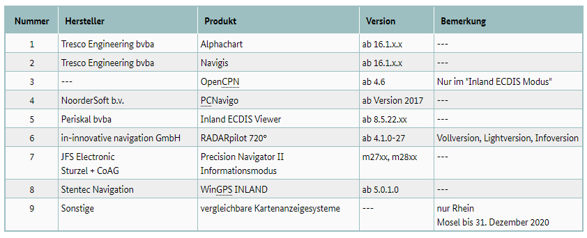
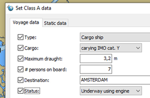
AIS Programming If you have an AIS Class A on board, you are required to enter the destination and the load in the AIS device. It is possible to easily set this up via WinGPS Inland. WinGPS Inland has a special AIS button bar with which you can quickly view the sailing status, the destination and more and adjust it directly. |
 |
Planning routes Simply set out a route by specifying your final destination and WinGPS Inland will plan a route from your GPS position, the dimensions of your ship, the bridges, locks and waterways into account. With multi-day routes you can indicate which hours / days you want to sail and which you do not, so that you can see at a glance where you are during, for example, the rest periods. By downloading the shipping notifications, the current obstructions are shown on the chart so you can adjust the route if necessary. | 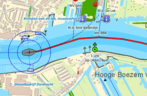 |
Tracks As soon as you have turned on the GPS receiver in WinGPS Inland, a route is automatically tracked. This allows you to always see when you have sailed where. This data is only stored locally and you can delete it if desired or save it in a backup. | 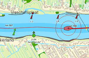 |
|
Marking zones With the help of the "alarm zones" in WinGPS Inland you can mark areas on the map yourself. You can indicate whether or not you can sail in the zone. If you go outside the indicated lines of the alarm zone, a visual and audible alarm will sound. This can be useful for dredging, when a certain area needs to be visited several times, when searching for a drowning person or when indicating areas that are not accessible. | 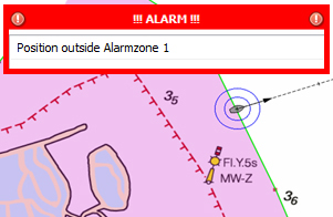 |
Expected soon In the coming period, we will be working hard on improving and expanding WinGPS Inland. Below is an overview of some of the functions currently being worked on. Subject to changes. |
|
Loaded and unloaded Whether your ship is loaded or unloaded can sufficiently influence the speed, depth and consumption of diesel. With WinGPS Inland you can save different profiles, which you can easily select as soon as you plan a route or sail. This immediately gives you a realistic picture of the ETA, consumption and the duration and distance of the possible route. |
Consumption meter Following the request from a WinGPS user, we have made a link between the consumption meter (flow meter) and WinGPS Inland. This allows you to directly see in WinGPS how much fuel is used per km. This is initially only tested for this specific type of consumption meter, after which we will examine to what extent this can also be applied to other consumption meters. |
|
|
BICS As an inland skipper you are probably familiar with BICS. It is a system that allows you to report electronically to the waterway managers, instead of via the VHF radio. We want to make it possible for you to do this via WinGPS Inland. |
Costs and updates
An up-to-date navigation program is important for a safe journey. Below is explained what the one-off costs are and which costs are involved during the annual updates.
WinGPS Inland
The WinGPS Inland navigation program costs € 499,- excl. VAT. |
Do you already own WinGPS 5 Navigator, WinGPS 5 Pro or WinGPS 5 Voyager? |
Inland Update Service We recommend that you purchase the "Inland Update Service" subscription with the navigation program WinGPS Inland. This costs € 365,- excl. VAT and is automatically renewed annually. With this update service you get:
|
Updating WinGPS Inland Do you have an older version of WinGPS Inland and do you want to update it without having or wanting to have an Inland Update Service? Then you can also separately upgrade WinGPS Inland to the latest version. During the winter months there is the special WinGPS Service Card, with which you can upgrade your WinGPS for less. You will be informed about this in due course. |
Technical information |
||||
WinGPS Inland:
| System requirements:
Programma updates: Read through the link below what has been changed each year in WinGPS Inland. |
If you want to be sure that WinGPS Inland will run on your system, you can first install our free WinGPS ENC Viewer. If this version works smoothly on your system, WinGPS Inland also works. You can download WinGPS ENC Viewer via this link. |