WinGPS Inland: professional navigation for inland shippers

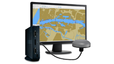
Do you already know WinGPS Inland? We have developed this professional navigation program especially for inland shippers, but it is also ideal for larger pleasure craft and coastal shippers. With this extensive route planner you create a complete professional navigation system for on board. We are happy to tell you more about this in this email.


Program your AIS-transponder
Changing the settings in your AIS Class A, including the current destination and load, can be easily and quickly programmed via WinGPS Inland.

The special AIS button bar allows you to quickly view and instantly adjust your AIS settings.

Use iENC
By combining the free iENC with DKW charts, you create a very complete chart image. Organize it entirely to your liking, using the S57 settings in WinGPS Inland for a nice and clear chart image.


Plot routes and sail them with current shipping messages
Simply plot a route by specifying your final destination and WinGPS Inland will plan a route from your GPS position, taking into account the dimensions of your ship, the bridges, locks and waterways. With multi-day routes you can set which hours / days you want to sail and which you do not, so you can see at a glance where you are during, for example, the rest periods.

By downloading the shipping reports, the current obstructions are shown on the chart and you can adjust the route if necessary.


Ship profiles
Whether your ship is loaded or unloaded can make quite a difference in the speed, draft and consumption of diesel. WinGPS Inland allows you to save different profiles, which you can easily select as soon as you plan a route or sail. This gives you a real-time view of the arrival time, duration, distance and the fuel consumption of the possible route.

Mark zones
With the help of the alarm zones in WinGPS Inland you can mark areas yourself on the chart. You can set whether or not you can enter it. If you go outside the indicated lines of the alarm zone, a visual and audible alarm will sound. Ideal during dredging, dumping, searching for a drowning person or for indicating areas that are not accessible to you.


Order WinGPS Inland now
The navigation program WinGPS Inland is a one time purchase of €499, - excl. VAT.

This includes the WinGPS updates during the first calendar year.

Or upgrade from WinGPS 5
Are you already in possession of WinGPS 5 Pro or Voyager (2017, 2018 or 2019)? Then you have the option to upgrade to WinGPS Inland for a special price. You will receive a €200 discount on the purchase price of WinGPS Inland.


Inland Update Service
We offer a subscription specially for users of WinGPS Inland. This will keep WinGPS Inland up-to-date, you will receive updates to the European waterways network, you will receive updated NL-tides every year and you will have access to the iENC server with which you can easily download and update iENC.


Complete navigation system for on board
Stentec is happy to help you make the right choice when it comes to navigation solutions. We offer ready-to-use laptops & mini PCs for on board, specially selected according to your wishes. The latest navigation software, sailing charts and USB GPS receiver are installed.

Constantly evolving
We are working hard to improve and expand WinGPS Inland. For example, we are going to make the link between WinGPS Inland and the CoVadem box possible. As a result, cooperative depth measurements are always available and up to date. Ideal for better predictions and sustainable, economically advantageous navigation.

We are also working on a link with BICS. This is a system that allows you to report electronically to the waterway managers, instead of via the VHF radio.