Release: DKW Imray-serie 2016 & DKW Internationaal UK1 2016

The new editions of the DKW Imray charts & DKW International UK1 are available. You can use these charts in WinGPS 5 as well as in WinGPS Marine.

The 2016 editions of the DKW Imray charts & DKW International UK1 can be purchased in our online shop. With the purchase of the 2016 versions you will automatically receive all updates for these charts, which will become available in the course of 2016.

Upgrades
If you have the last editions of the charts, we have a special offer to upgrade to the 2016 editions. While in our online shop, choose your current edition at the 'upgrade from' option to receive the offer.

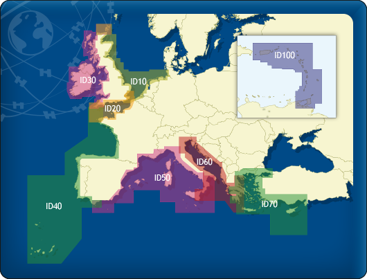
DKW Imray series 2016
Since 2009 Stentec releases digital versions of the Imray series. These are based off of the paper charts and have the same, recognizable colors. The advantage of these maps is covering a large area with just one set.

Below you will find a summary of all 2016 versions of the Imray charts. The most important changes are depth images of estuaries, changes in obstructions and the additions of the Notices to Mariners.

DKW ID20 English Channel

DKW ID30 British Westcoast & Ireland

  • 2300.6 - River Exe
  • 2300.9 - River Dart
  • 2400.3 - Isles of Scilly
  • 2400.5 - Salcombe
  • 2400.6 - River Yealm
  • 2400.7 - River Fowey
  • 2400.11 - Helford River
  • 2400.12 - Falmouth Harbour
  • 2400.13 - Plymouth Harbour
  • 2400.14 - Saint Mary's, Tresco & Surrounding Islands

  • C52 - Cardigan Bay to Liverpool
  • C53 - Donegal Bay to Rathlin Island
  • 2400.3 - Isles of Scilly
  • 2400.6 - River Yealm
  • 2400.11 - Helford River
  • 2400.12 - Falmouth Harbour
  • 2400.13 - Plymouth Harbour
  • 2400.14 - Saint Mary's, Tresco & Surrounding Islands

DKW ID40 Atlantic coast France,
Portugal to Gibraltar

DKW ID50 Mediterranean West

  • C20 - Strait of Gibraltar to Archipelago dos Acores & Islas Canarias
  • C42 - La Rochelle to Santander
  • 2400.3 - Isles of Scilly
  • 2400.6 - River Yealm
  • 2400.11 - Helford River
  • 2400.12 - Falmouth Harbour
  • 2400.13 - Plymouth Harbour
  • 2400.14 - Saint Mary's, Tresco & Surrounding Islands
  • E3 - Arquipelago da Madeira

  • M10 - Western Mediterranean
  • M19 - Capo Palinuro to Punta Stilo

DKW ID60 Mediterranean Central

DKW ID100 Caribbean East

  • M10 - Western Mediterranean
  • M34 - Golfo di Venezia

  • A27 - Antigua
  • B3 - The Grenadines
  • B31 - Bequia to Carriacou


DKW International UK1 English & Scottish Eastcoast 2016
The popular DKW International UK1 English & Scottish Eastcoast is also available, including several updates during the year. In most instances the updates consist of the latest Notices to Mariners from the UK hydrographic office. The modified charts consist of, amongs others: parts of the Thames , Great Yarmouth and Lowestoft. These charts now show the latest depth images and buoys.

Below is a brief summary of the updated charts in the DKW Internationaal UK1 2016 edition.

  • Kaart 152: River Tyne to River Tees
  • Kaart 735: Firth of Forth, approaches to Leith & Burntisland
  • Kaart 1188: River Humber: Spurn Head to Immingham
  • Kaart 1191: River Tyne to Flamborough Head
  • Kaart 1200: Wash Ports
  • Kaart 1481: River Tay: Dundee & approaches
  • Kaart 1543: Winterton Ness to Orford Ness
  • Kaart 1698: Dover
  • Kaart 1935: Approaches to Blyth, river Tyne & Sunderland
  • Kaart 2581: Southern approaches tot Scapa Flow
  • Kaart 3496: River Humber: Immingham & Hull
  • Kaart 3497: River Humber: Immingham to Humber Bridge & de rivers Ouse and Trent