


Why this newsletter?
With this newsletter we would like to inform you about the coming 2012 editions of WinGPS 5.
During our open door day on December 17th a test version of Voyager was demonstrated.
WaterwayNetworkEditor in action 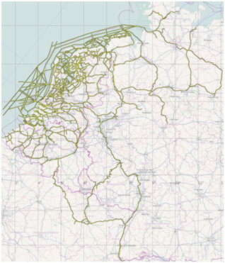
With the new network editor the so called design of the water way network is improved significantly and expanded with the Belgian water ways and a big part of Germany. Currently the bridges and locks are added to Belgian network.
An exporter is written which enables to convert the network to the WinGPS 5 planning network.
The European network is now divided in:
NL Inland, IJsselmeer/Markermeer, Waddenzee (NL, DE, and DK), North sea, Belgium, Luxembourg, Germany, France, Denmark, Sweden and East sea and Great Britain.
WinGPS 5 2012 allows these areas to be activated separately.
WinGPS 5 Voyager 2012 test version
An important mile-stone is the release of the WinGPS 5 Voyager test version. This version also contains all the Pro and Navigator options. For the first time an up to date, good visible network was realized for both yachting as well as commercial shipping.
The network on the IJsselmeer/Markermeer is expanded with many yachting tracks. Furthermore the channels and buy lines are corrected. The German wadden area is added.
In 2012 the following areas will be further constructed: North East Sea channel, Ems-Jade Channel, Belgian water ways, Cruising Area Rijn-Moezel-Saar-Neckar. Furthermore North west Germany to Lübeck - Maagdenburg with Ems, Weser, Elbe en Mittelland channel.
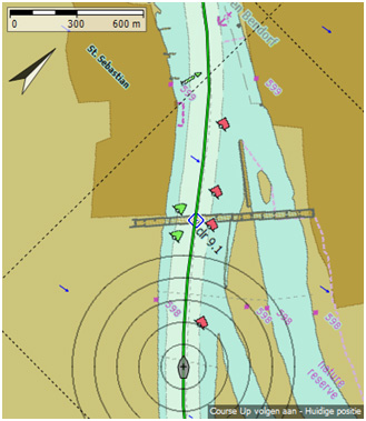
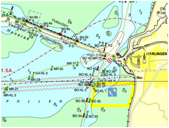
The extensive network is ideal for route planning. For example: to the East sea via Brunsbüttel and Kiel.
 Planned routes on your map
With route management you can visualize routes on the map. The route is shown in straight lines connected with way points. This will work just fine for open leg routes. A route on the inland water ways always consists of a point of departure and your destination. The detailed planned route over the network will be replaced by a dotted line which indicates the precise route shape. This shape depends on departure time and other data. Only when the route is started or adjusted it will be drawn over the network again. Possibly in another shape due to a changed departure time. New in the 2012 edition is the shape of the last planned route will be saved, so it always can be shown completely and not in dotted lines anymore. Many users find it very important the shape of the route is recognizable. The planned route can be adjusted in the edit mode.
Stentec has developed a procedure to create DKW2 chart sets from Inland ECDIS charts. This allows the sailing area to be extended with the most important European rivers and channels. During the production process a choice is made concerning scale and color depths to create an
DKW German Rhine, Moezel, Saar and Neckar
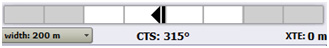
For the DKW2 Chart sets of the Rhine is chosen 1:20.000. For the tributaries this is 1:10000. The quality is better than of the frequently used Rhine atlas. It is no longer necessary to go to the next page every 8 km. The chart will follow. The route network on the Rhine and tributaries on the DKW ENC chart is accurately shown in the middle of the channel. When following the route you can sail along the mostoptimal route using the XTE bar.
 Openseamap chart sets(DKW OSM)
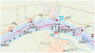
Openseamap is a community of yachtsmen who develop duty free navigation maps. With DKW Builder also DKW2 charts for WinGPS can be build of Openseamap charts. Stentec has developed several OSM chart sets of a.o. the German rivers.OSM charts contain less detailed water way information compared to DKW ENC charts, but more information of the surrounding area. Besides ENC charts also smaller charts for yachting are available. Below an OSM chart and on the right the ENC while sailing along the Rhine and Ems to Kiel in simulation mode.
Water way network of great value for navigator
The WinGPS 5 water way network is developed with help from experienced skippers. Not only for the inland waterways, but also The Wadden and a journey to the East sea. The route network can therefore be seen as a valuable interpretation of the map. Important for safety and ideal to prepare your journey. As with the BaZ updates we cannot guarantee 100% correctness and with that safety. The network is to be used as a navigation tool. You are always able to deviate from the network and plan your own (open leg) routes.
More visibility with Sun flare resistant AIS
The strong increase of AIS among commercial shipping and yachting leads to increased safety. AIS combined with WinGPS enables you to see a ship going down a river from afar. It will also see you if you have an AIS transponder.
The new Pro and Voyager version have settings to avoid bad visibility on the map due to busy AIS traffic. Names of stationary AIS ships can be switched off. Yachting (Class B) and stationary ships can be permanently excluded. When zooming out, the names become smaller until they disappear. The SOG can now be shown on the map and the course of AIS ships can be switched off. The standard setting will give a clear chart visibility, also in case of passing by harbors and anchorages. Built in routines help ignore damaged AIS messages due to sun flares.
Last NLTides database for WinGPS 4
For the last time a new NLTides database will be available for WinGPS 4 Pro and Voyager. A set-up with the astronomical tides can be downloaded from our download section on our website. The new NLTides database is integrated in WinGPS 5 Pro and Voyager 2012. A good reason to buy an upgrade to WinGPS 5.
Online quotations! 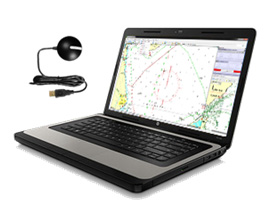
Our new online service gives you the possibility to request a quote or personal advice. We will provide you with an offer containing the best navigation solution.
Think of a new laptop on board provided with WinGPS and all digital charts for your holiday in 2012. From an energy-efficient 10” laptop to a robust 15, 4” or 17” laptop. A ready to use package which can be delivered at home or you can pick up in our shop in Heeg. The quotations will be available in English as soon as possible.
www.stentec.com/nl/contact/offerte-aanvragen
 Cruising, motor boating or regatta sailing
When switching from a cruising sailing boat to a motor boat or racing boat, you can adjust WinGPS very easily under the following settings: File/Properties/Ship. When you choose for motor boat, all options for sailing will be excluded. This way the menu will appear as the WinGPS 5 Pro menu. Without polar diagram, but with the convenient route optimalization. The Magic button can be used to minimize fuel consumption or the quickest
What is a sailing boat’s polar diagram?
Many Voyager navigators only see the polar diagram when they select their type of sailing boat. When the gribfiles are updated, Voyager calculates how long it will take to navigate your boat along the planned route. In case of low speed, motor operation can be can be switched on. The polar is used to determine the optimal route, departure and arrival time.When you sail faster or slower than planned, you can reduce or enlarge your polar diagram with the button at the bottom left. The wind speed of a standard polar is defined at 10m height above the water surface. You can correct a deviating Grib-windspeed using factor level in GRIB manager.
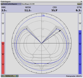
In case of comparison with your wind meter, take into account that the wind speed in the mast head due to wind shear can be 20% higher than at 10m high. This factor is of importance when you use your wind velocity meter input to keep your ship up to speed using your polar diagram. In case of a polar diagram like below the WOW (wind over water) comes from above. The arrow shows the speed of the ship compared to the wind. In this case almost on the wind over starboard. The wind course CRS and the blue polar diagram are both controlled by the wind velocity meter. The blue bar on the right shows the ship speed is faster than the polar diagram. The red bar on the left shows the VMG (head to wind speed) is lower than it should be.
WinGPS 5 Voyager contains polar diagrams for over more than1400 different boat types. a.oBaltic, Bavaria, Beneteau, Breehorn, Contest, Dehler, Dufour, Elan, Etap, F&F, Feeling, First, Friendship, Gib’Sea, Grand Soleil, Halberg Rassy, Hanse, Hunter, J22-92, Jeanneau, Kolibri, Koopmans, Maxi, Nicholson, Oceanis, Optima, Solana, Sigma, Spirit, Standfort, Sunfast, Sun Odyssey, Swan, Sweden, Trintella, v.d. Stadt, Victoire, Waarschip, Winner, X-yacht.
Find your sailing boat type on our polar list at download/documentation on our website.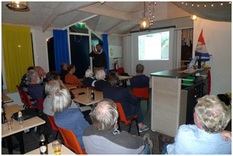 Workshops & lectures WinGPS 5
This fall the WinGPS workshops and Lectures in Heeg and Loosdrecht where well attended. End March and April 2012 new workshops will be planned. Ideal preparation for the sailing season. For more information and to sign up please consult our agenda. A crew member can come along for free.January 10th and March 13th there will be a WinGPS Voyager introduction night and a WinGPS 5 Pro workshop in Huizen. Only for NvvT members. On April 10th a lecture about laptop navigation with WinGPS 5 and AIS is planned. It will take place at WSV Giesbeek.
 New hardware in 2012
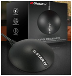
The Globalsat BU353 s4 will be the successor of the popular and reliable BU353 GPS Mouse. The new generation high sensitive sirf 4 chip combined with EGNOS ensures the best position accuracy, also under lesser conditions like poor reception in a steel cabin or under a bridge.
Spotted on the Dutch market. A 27” LED monitor from Samsung with an impressive 2560*1440 pixels. A non-reflective screen with high brightness. Because of its size it seems the perfect replacement for charts on board
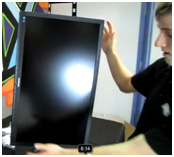
The screen can be tilted 90 degrees and mounted on a ship wall. Which WinGPS user will be the first to test it on board?
Additional measurements for the Vaarkaart Fryslân
In collaboration with the Province Stentec is developing digital charts of Friesland with a unique depth image. Source material is the depth measurements carried out in 2009 as part of the Frisian Lakes Project. On the advice of Stentec additional measurements have been done to be able to create complete and up-to-date chart of the Frisian Lakes. Due to delay of delivery of the TOP25 charts, the release on Boot Holland 2012 is not definitive yet. Stentec will improve the depths annually.
www.wingps.de and Boot Düsseldorf
The German WinGPS website of our agent Matthias Jürgens from Jürgens Yacht Service went online this month. The Stentec products range in the online shop is aimed at German users. Together with Stentec Matthias Jürgens will be present at Boot Düsseldorf at the Stentec stand 11E3. The WinGPS 5 2012 version will be demonstrated.
Expected WinGPS 5 2012 updates
WinGPS 5 Navigator:
- Improvement and expansion of route network
- Sail along network route with XTE bar and CTS
- Energy-efficient NMEA monitor.
- More stable iPad connection.
- Network routes always shown completely.
WinGPS 5 Pro (in addition to Navigator):
- Acceleration optimal route with NLTides.
- Tide database 2012.
- Optimized visibility in case of busy AIS traffic
- Tide coupling for network route points.
WinGPS 5 Voyager (in addition to Pro):
- Easy adjustable for tour sailing, motor boat or regatta sailing.
- High resolution HIRLAM files in 2012.
- WinGPS 5 Lite for 2012 charts
Please send your questions and comments to: w.kuik@stentec.com or call 0515-443515


