


- News
- E-mail list
- Signup for our newsletter
- Stentec news
- News
- Developers Blog
- WinGPS
- WinGPS series
- WinGPS versions
- WinGPS specifications
- For Windows
- WinGPS Lite
- WinGPS Navigator
- WinGPS Pro
- WinGPS Voyager
- For Android
- WinGPS Marine
- WinGPS Marine Plus
- For iOS
- Apps for iOS
- WinGPS Marine
- WinGPS Marine Plus
- DKW 1800 series
- Vaarkaart Friese Meren
- Service and upgrades
- Service Subscriptions
- WinGPS Service Card
- WinGPS Yacht Navigator
- Charts
- Chart overview
- DKW Inland waters
- DKW The Netherlands
- DKW Friese meren
- DKW Amsterdam
- DKW Biesbosch
- DKW Belgium
- DKW Northern France
- DKW Southern France
- DKW Northeast Germany
- DKW Northwest Germany
- DKW Southwest Germany
- DKW Rhine and Moselle
- DKW Danube 1-West
- DKW Danube 2-Central
- DKW Danube 3-East
- DKW Coastal waters
- DKW 1800 series
- DKW 1600+
- DKW UK1 English & Scottish Eastcoast
- DKW German Bight
- DKW German Baltic coast
- DKW Imray series
- DKW Delius Klasing series
- NV-Verlag series
- Exclusive for Android
- Subscription - DKW the Netherlands
- Chart apps
- Other
- ADAC Marina Guide
- Hardware
- Simulators
- Shop
- Downloads
- Support
- Downloads
- Help pages
- Documentation
- System Requirements
- Availability GRIB files
- Frequently asked questions - FAQ
- WinGPS 5
- WinGPS Marine (Android)
- WinGPS Marine (iOS)
- Installation help
- WinGPS 5 (Windows)
- WinGPS Marine (Android)
- Tips
- Offline installation DKW charts (Windows)
- Installation ENC charts (Windows)
- Connecting SD card (Android)
- NV Verlag charts
- Offline NOAA Charts
- Download TeamViewer
- Contact
- Contactform - Helpdesk
- Callback Service
- Commercial Shipping
- Details
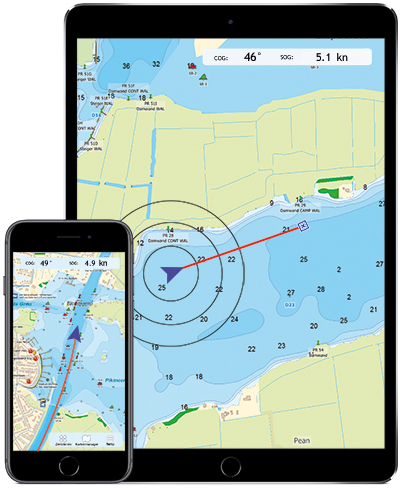
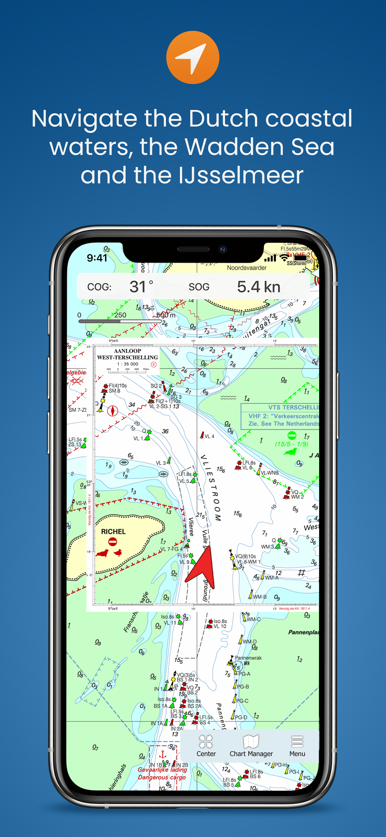
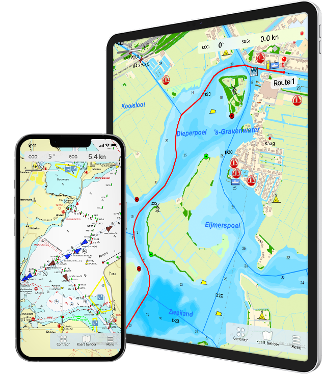
Navigate on your iPad and iPhone
Since 2019, the navigation program WinGPS is also available in the Appstore. In addition to WinGPS 5 on the laptop and WinGPS Marine on an Android device, you can also navigate on an iOS device!
On this page we would like to tell you more about our various navigation apps for your iPad and iPhone. At the bottom of the page we will keep you informed of the latest developments. Onderaan de pagina zullen wij u op de hoogte houden van de laatste ontwikkelingen hierin.
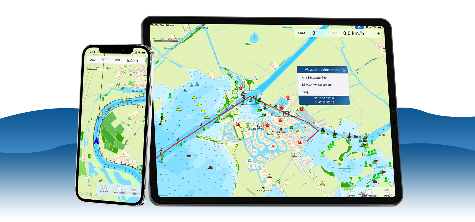
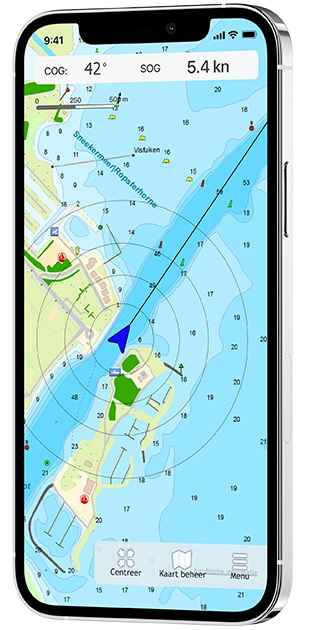
WinGPS Marine for iOS
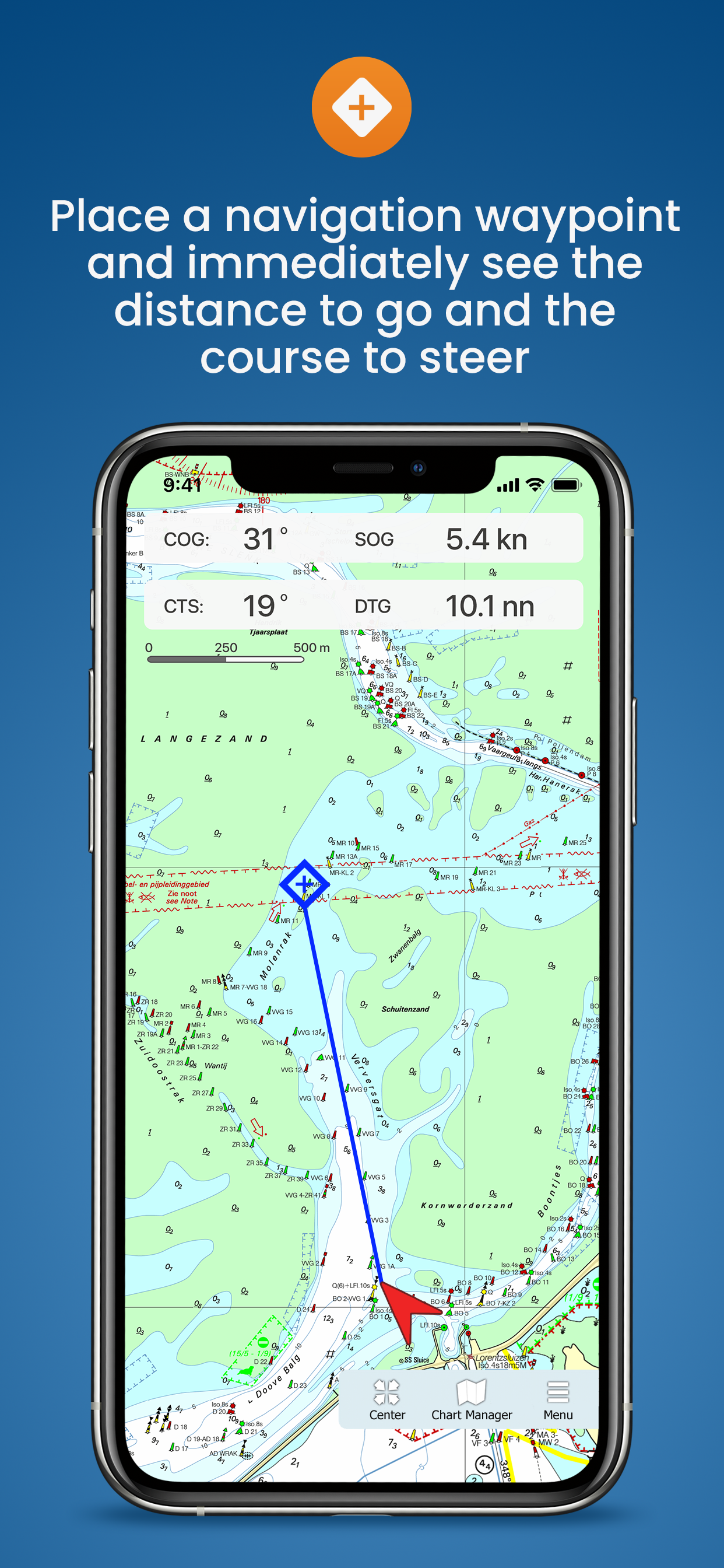
Get to know the navigation app WinGPS Marine for free and view your navigation charts, position and speed, among other things. Plot a navigation waypoint so that you immediately see the course-to-steer and distance-to-go. Ideal for smaller trips or as a backup.
If you choose the more extensive WinGPS Marine Plus app, you can plan routes, download GRIB-files and connect your AIS. Over time, this app will be expanded with functions such as current and tide data and connecting other on-board instruments. In this way you can create a complete back-up navigation system on board.
|

|
|
|
|---|---|---|---|
| GPS position, speed, course and distance over ground | |
|
|
| Tracks | |||
| Distance Circles | |||
| Navigation waypoint | |||
| Waterway network | |||
| Routes | |||
| Connect AIS | |||
| Course-up mode | |||
| GRIB-files from NOAA | |||
* Saving as well |
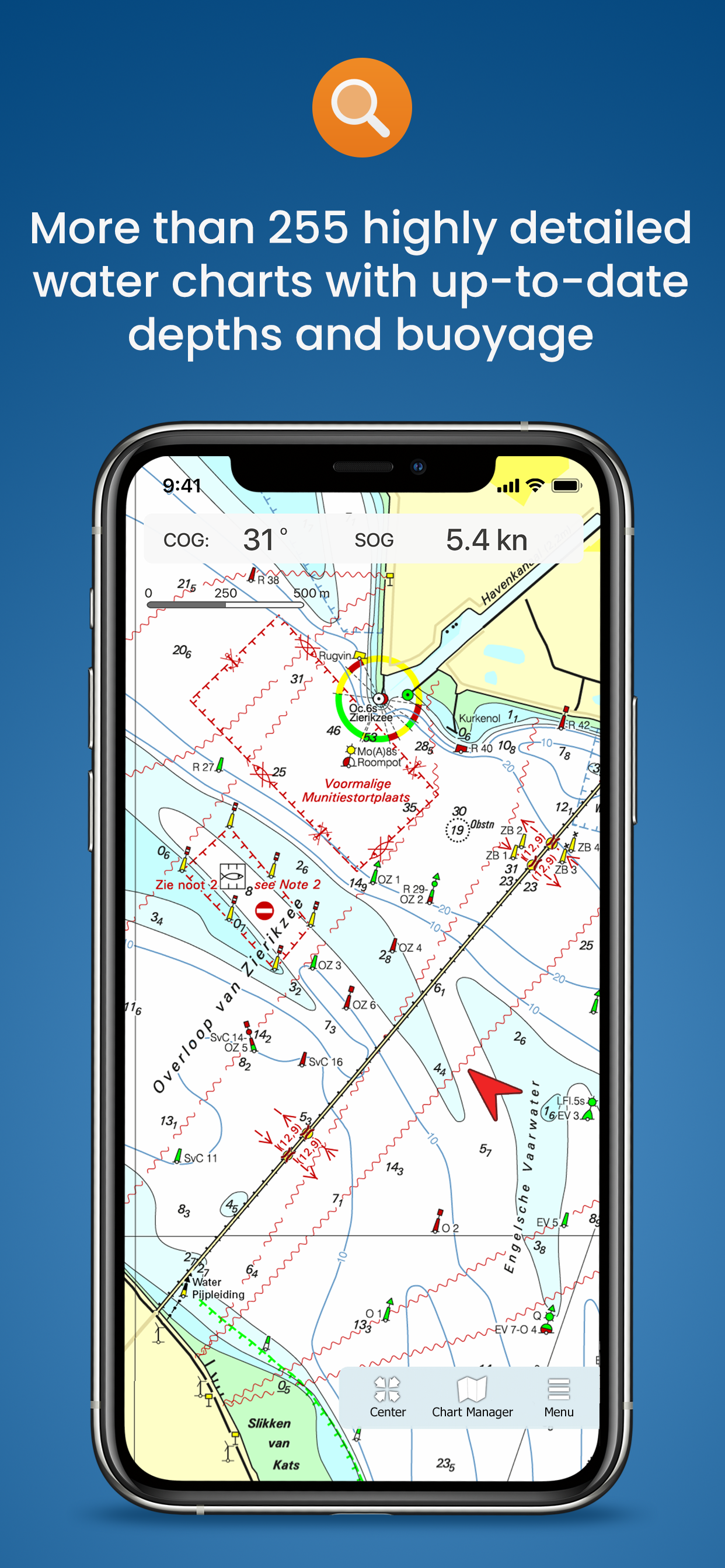
Charts in WinGPS Marine
The charts you can use in these apps are Stentec's own DKW charts. For example, the well-known DKW 1800 series including weekly update service or the free DKW Vaarkaart Frisian Lakes.
In WinGPS Marine you can also use Apple's free online charts for orientation. You can download the DKW charts directly in the app and use them for navigation, after you have logged in with your Stentec account.
| Note: Only 2018 and newer charts can be used in this app. Do you have older charts? Upgrade your charts in our online shop. Click here to upgrade your charts. |


Latest developments
|
GRIB-files from NOAA in WinGPS Marine Plus Posted on August 3, 2023
WinGPS Marine Plus
In WinGPS Marine you can now place a navigation waypoint on the waterway network, after which a route will automatically be drawn over the intervening waterways. 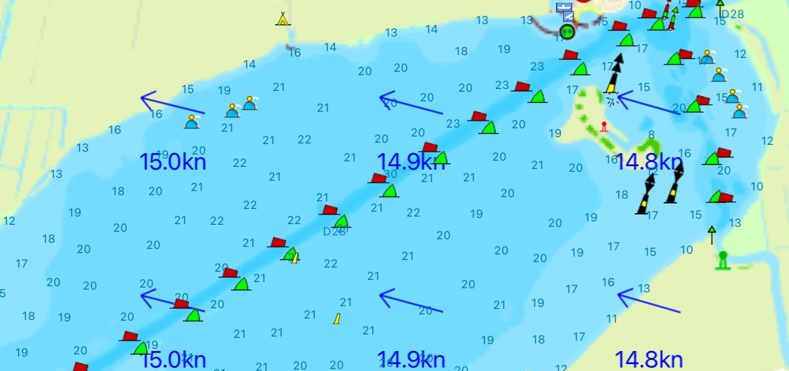
|
Routes over the waterway network in Marine Plus Posted on June 27, 2022
WinGPS Marine Plus
In WinGPS Marine Plus you can now plan a route over the waterway network, taking into account the dimensions of your ship, the waterways and the bridges & locks. 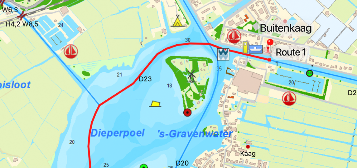
|
|
Navigation waypoint on waterway network in WinGPS Marine Posted on June 27, 2022
WinGPS Marine
In WinGPS Marine you can now place a navigation waypoint on the waterway network, after which a route is automatically drawn over the intermediate waterways. 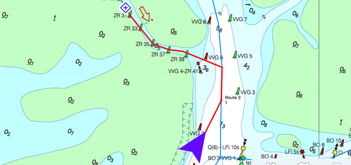
|
Waterway network in WinGPS Marine and Marine Plus Posted on august 9, 2021
WinGPS Marine and Marine Plus
The WinGPS Marine and WinGPS Marine Plus apps now also include the waterway network with information about waterways, bridges and locks. 
|
Posted on December 17, 2020
WinGPS Marine Plus
Download the more extensive navigation app WinGPS Marine Plus in the Appstore from now on! You can already plot routes, connect your AIS to it and switch on the Course-up mode. Over time, more functions are added, such as GRIB files and linking other on-board instruments. 
|
Update WinGPS Marine Posted on Ocotober 25, 2019
WinGPS Marine
From now on you can also view your sailed routes, turn on distance circles and place a navigation waypoint in WinGPS Marine. 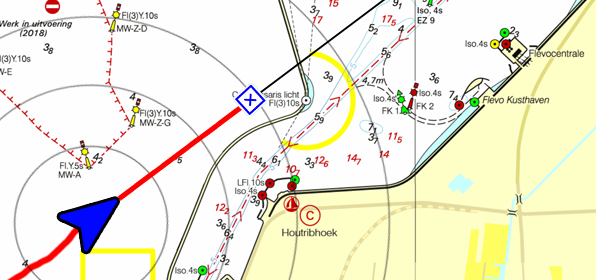
|
| | |
|
Release WinGPS Marine Posted on June 11, 2019
WinGPS Marine
Download the free navigation app WinGPS Marine now in the Appstore! Now you can load all your DKW charts and view your position, course and speed. More features will be added in upcoming updates. 
|
Bèta WinGPS Marine Posted on March 15, 2019
WinGPS Marine
The beta version is online and is being tested by WinGPS users. The feedback from this is used to be able to release a solid version of WinGPS Marine in the short term. 
|
- Details
|
Vaarkaart Friese Meren Available for free for iPad and iPhone. |
|
|

 |
Vaarkaart Friese Meren for iOS This chart is perfect when you are planning a trip on the Frisian Lakes. Great while renting a boat, but also for skippers and crew of sailing boats, motorboats and sloops on the Frisian Lakes. Even while using a canoe or kayak or planning a fishing trip on the lakes this chart offers a clear image of your position of the beautiful Frisian landscape. The area this chart covers is from Stavoren, Makkum, Grou to Lemmer. Navigate on the Heegermeer, Fluessen, Morra, Oudegaster Brekken, Zwarte Brekken and Witte Brekken, Sneekermeer, Koevordermeer, Tjeukemeer, Langweerderwielen, Pikmeer/Wijde Ee and the many ditches, canals and pools. Depth image Processed within this chart is a unique, clear depth image received from the Friese Meren Project with beautiful colored depth levels and numbers along the water ways. Developed by Stentec in collaboration with Provincie Fryslân with the most recent depth measurements. This is a detailed chart with a scale of 1m/pixel, comparable with 1:3.000 on screen. The database accompanied with the chart has 3.393 waypoints and offers all kinds of useful water sports information. For example harbours, buoys, docks, water sport campsites and gas stations. |
Popular sailing chart for the Frisian Lakes
The DKW Vaarkaart Friese Meren has been available for Android and Windows since 2014 and has already been used by more than 60,000 water sports enthusiasts. More information about the Vaarkaart Friese Meren can be found at www.vaarkaartfriesemeren.nl
System requirements
Check via the link below if your device is suitable for this chart app. This app has the same system requirements as WinGPS Marine for iOS. In addition, you should take into account the size of the DKW Frisian Lakes charts. Check our online shop for the current size of these charts. |
Note: not every iPad has a built-in GPS receiver. If your device does not have an internal GPS receiver, you can use a bluetooth GPS receiver |
- Details
|
DKW 1800 series for iOS! Up to date all year round. |
|
 |
Charts
After purchasing the app you can immediately download all DKW 1800 charts and start using the app for navigation on board. The charts are linked to your Stentec account and can therefore also be used with WinGPS for Windows and WinGPS Marine for Android.
| Note: the updates for the DKW 1800 charts will be released weekly. Do you have the edition of last year? Then you can upgrade to the new edition for a special upgrade price in our online shop, which will also provide you with weekly BaZ updates for the charts. |
System requirements:
Check via the link below if your device is suitable for this chart app. This app has the same system requirements as WinGPS Marine for iOS. In addition, you should take into account the size of the DKW 1800 series charts. Check our online shop for the current size of these charts.
|
Note: not every device mentioned above has a built-in GPS receiver. If your device does not have an internal GPS receiver, you can use a bluetooth GPS receiver |
WinGPS Marine
Do you also want to sail outside the 1800 series area? Then we recommend WinGPS Marine: the free navigation app for iOS. Here you can also load other DKW charts and use them for navigation. WinGPS Marine can be upgraded, after which you can also set routes, download GRIB files for weather forecasts and link AIS.
- Details
| |
WinGPS Marine PLUS Navigate on your iPad and iPhone. |
|
|


Charts
The charts that can be used in this app, are Stentec’s own DKW-charts. For example the free chart DKW Frisian Lakes or the well-known DKW 1800-series for the Dutch coastal waters, including weekly update services.
At the first start-up of the app, you will be asked to log in with your account. The free default online maps from Apple are available in the app for orientation. The DKW-charts, which are connected to your account, can be downloaded directly in this app and be used for navigation.
| Note: only charts from 2018 and newer can be used in this app. Do you have older charts? Then you can renew them in our online shop. Click here to renew your cards > |
|
System requirements: |
| Note: not every ipad has a built-in GPS receiver. If your device does not have an internal GPS receiver, you can use a Bluetooth GPS receiver |
Let us know what you think
In the coming period, the app will of course be further upgraded, optimized and new (possibly paid) features will be added, for example GRIB files, stream and tidal information and the option to connect other board instruments. We would like to continue to receive your feedback about the current version and any wishes for future versions via the feedback form.
- Details
|
WinGPS Marine!
|
  |
WinGPS Marine for iOS
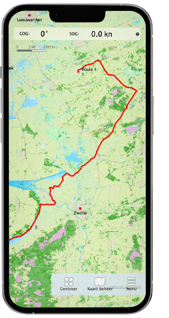
Ideal for navigation on your sloop, sailing yacht, motor ship or canoe. WinGPS Marine for iOS is our first app for the iPad and iPhone. The app originated from the beta version that has been enthusiastically tested by many WinGPS users.
The iOS app is ideal for use with our open water charts, such as the popular DKW 1800 series. Now that the waterway network has been added, the app is also suitable for use on inland waterways, such as with the DKW Vaarkaart Nederland.
Here's an overview of all our apps for iOS, including the latest news about them.


Charts
The charts that can be used in this app, are Stentec’s own DKW-charts. For example the free chart DKW Frisian Lakes or the well-known DKW 1800-series for the Dutch coastal waters, including weekly update services.
At the first start-up of the app, you will be asked to log in with your account. The free default online maps from Apple are available in the app for orientation. The DKW-charts, which are connected to your account, can be downloaded directly in this app and be used for navigation.
| Note: only charts from 2018 and newer can be used in this app. Do you have older charts? Then you can renew them in our online shop. Click here to renew your cards > |
|
System requirements: |
| Note: not every ipad has a built-in GPS receiver. If your device does not have an internal GPS receiver, you can use a Bluetooth GPS receiver |
Let us know what you think
In the coming period, the app will of course be further upgraded, optimized and new (possibly paid) features will be added. We would like to continue to receive your feedback about the current version and any wishes for future versions via the feedback form
News
- Always your navigation at hand with WinGPS
- DKW Vaarkaart Nederland 2026 edition now available!
- NEW: WinGPS 6 - 2026 is now available for download!
- DKW German Bight & Baltic Coast 2026 available!
- Is your WinGPS 6 ready for 2026?
- WinGPS Inland 2026 now available!
- Major update for DKW UK1 English East Coast, and more news
- News and updates
- New DKW charts for 2026!
- Refer a fellow skipper to WinGPS 6 and receive €50 off!

Harinxmastrjitte 29
8621 BJ HEEG
The Netherlands
T +31 (0) 515 443515


Copyright © Stentec Software. All rights reserved.
By using this website you acknowledge that you agree with our user agreement.