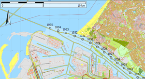
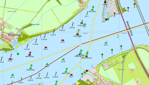
With this publication we inform you about this new navigation chart of the Netherlands which you can buy in our online shop.
Detailed TOP10 subsurface
The chart is based on the June 2012 edition of the TOP10 of the land register and shows by zooming in almost the same details as Google Earth. The 200dpi redering on 1:25.000 scale allows you to zoom in that much, that your own vessel and the other AIS vessel can be located on scale on the smaller waterways. One pixel on the chart is 2m, that makes that a waterway of 20m width consists 10 pixels. That makes it Ideal for route planning and navigation with WinGPS 5. Because of precise calibration we tried to reach a precision on a few pixels (about 5 metres). On most locations the precision could be under 10 metres.
 The chart contains a coordination grid with 1 minute spacing. This is useful for the orientation of the printed maps. Please be informed to activate the option “Visible waypoints” in the print menu.
 The chart contains a coordination grid with 1 minute spacing. This is useful for the orientation of the printed maps. Please be informed to activate the option “Visible waypoints” in the print menu.
Extension on the 1800-series
The Vaarkaart NL is an inland extension on the 1800-series. In the Vaarkaart NL the IJsselmeer, Wadden, Zeeland and the North Sea Coast will be partly covered but contains besides buoying no depth information. This waterchart will not include a weekly BAZ update service as the DKW 1800. Every year in springtime a new edition of the DKW Vaarkaart Nederland will be released. As the 1800 series Mercator projection is used with chart date WGS84.Difference with DKW ANWB 2010
ANWB 2010 is based on TOP5Raster chart of 2009. The fundaments for the digital ANWB chart is a paper version which is also used for the ANWB App. Because of the readability buoying along a fairway and also the width of small channels are drawn displaced. Vaarkaart NL is about a factor 4/5 more exact, up-to-date and the buoying are positioned precisely as registered by the caretaker. The ANWB chart is drawn in National Triangulation (Rijks Driehoek RD) projection, which not always gives a correct connection per chart part. Also the ANWB chart is not provided with GPS-coordination grid.Difference with Vaarkaart Fryslân
Vaarkaart Fryslân shows more details then the Vaarkaart Nederland with depths, lines and parts of the “Friese Meren Project”. Also Marrekrite locations and a full wind turbine file. Vaarkaart Fryslân has to be seen as a detailed extension on the Vaarkaart Nederland. If you already have purchased our Vaarkaart Fryslân we offer a 10 euro discount on the Vaarkaart NL 2012.Chart of 20m height and 10m width
 The DKW2 chart contains 41 chart blocks of 20.000*20.000 pixels that makes 2,5 by 2,5m height per Block. When pasting the Vaarkaart NL on the wall it will be a size of 20m high and more than 10m wide. Because of the DKW2 compression the 45GB pixels will be compressed to a chart archive file (CHV) which will fit, with 3 GB, very well on a DVD.
 Easy installation
Because the CHV files will not get larger than 2GB they are split in a CHV and CHV files which belongs in the same folder. The installation with the DKW Manager is as easy as small files. It only takes a little longer. At the end of the installation procedure the Waypoint database will automatically be installed. This can be turn on or off, choosing Waypoint group manager, at your choice.Largest Buoing file for the Netherlands
In the last test version the waypoint database consists out of 22.000 waypoints that means 11.000 for buoying, 3000 kilometer raaipoints, 1400 depth designations and 6000 VIN moorings and harbours with VHF channels. Also windmills and water sports campings. The buoying file could be the largests one available for the Netherlands and exists out of buoying of the risserver, Province Fryslân and local buoying of spring 2012.From testchart to fully completed chart for WinGPS 5
To the database of the test chart an update will be added of VHF channels, yacht harbours and signs along the waterways originated from the risserver charts of ‘Rijkswaterstaat’. The route planner network will also be adapted for the rest of the Netherlands, just as it is already adapted for the Vaarkaart Frysân. Especially the old VIN network will be adjusted. This makes the Vaarkaart NL an ideal chart for the WinGPS route planner.


