


- News
- E-mail list
- Signup for our newsletter
- Stentec news
- News
- Developers Blog
- WinGPS
- WinGPS series
- WinGPS versions
- WinGPS specifications
- For Windows
- WinGPS Lite
- WinGPS Navigator
- WinGPS Pro
- WinGPS Voyager
- For Android
- WinGPS Marine Lite
- WinGPS Marine
- WinGPS Marine Plus
- For iOS
- Apps for iOS
- WinGPS Marine
- WinGPS Marine Plus
- DKW 1800 series
- Vaarkaart Friese Meren
- Service and upgrades
- Service Subscriptions
- WinGPS Service Card
- Charts
- Chart overview
- DKW Inland waters
- DKW The Netherlands
- DKW Friese meren
- DKW Amsterdam
- DKW Biesbosch
- DKW Belgium
- DKW Northern France
- DKW Southern France
- DKW Northeast Germany
- DKW Northwest Germany
- DKW Southwest Germany
- DKW Rhine and Moselle
- DKW Danube 1-West
- DKW Danube 2-Central
- DKW Danube 3-East
- DKW Coastal waters
- DKW 1800 series
- DKW UK1 English & Scottish Eastcoast
- DKW German Bight
- DKW German Baltic coast
- DKW Imray series
- DKW Delius Klasing series
- NV-Verlag series
- Exclusive for Android
- Subscription - DKW the Netherlands
- Chart apps
- Other
- ADAC Marina Guide
- Hardware
- Simulators
- Shop
- Downloads
- Support
- Downloads
- Help pages
- Documentation
- Availability GRIB files
- Frequently asked questions - FAQ
- WinGPS 5
- WinGPS Marine (Android)
- WinGPS Marine (iOS)
- Installation help
- WinGPS 5 (Windows)
- WinGPS Marine (Android)
- Tips
- Offline installation DKW charts (Windows)
- Installation ENC charts (Windows)
- Connecting SD card (Android)
- NV Verlag charts
- Offline NOAA Charts
- Download TeamViewer
- Contact
- Contactform - Helpdesk
- Callback Service
- Commercial Shipping
- Details
| DKW Vaarkaart Nederland 2024 optimal for WinGPS 6 |
|
The 2024 edition of the DKW Vaarkaart Nederland is now online! In this article we would like to tell you more about the new functions, which can be optimally used, especially in the 2024 edition of WinGPS 6. Equipped with a current TOP10NL based on the most recent aerial photographs from the land registry, DKW Vaarkaart Nederland 2024 has been improved on a large number of points compared to the previous edition. Optimized for CourseUp and HeadUp sailing.
More recent depths of the Frisian Lakes
Sector and lighthouse lights as a waypoint group.
New depth image of the Wadden Sea.
Classification of DKW Vaarkaart Nederland 2024 in images and in chart management 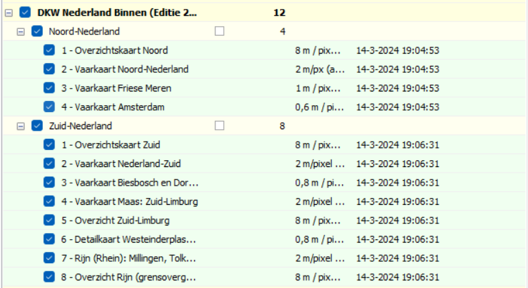
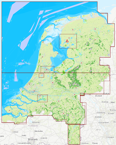
New: Detailed chart of Westeinderplassen, South Limburg and a separate border crossing at Lobith. 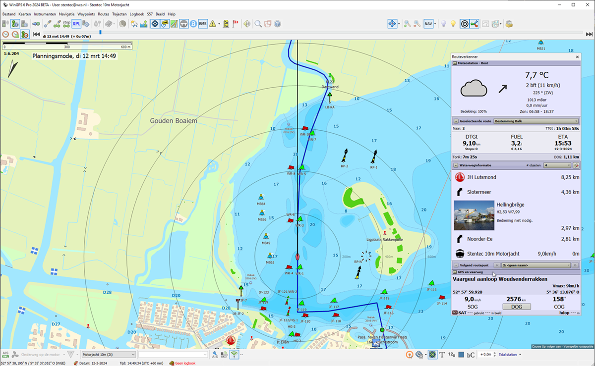
Vaarkaart Netherlands 2024 is optimized for CourseUp and HeadUP. 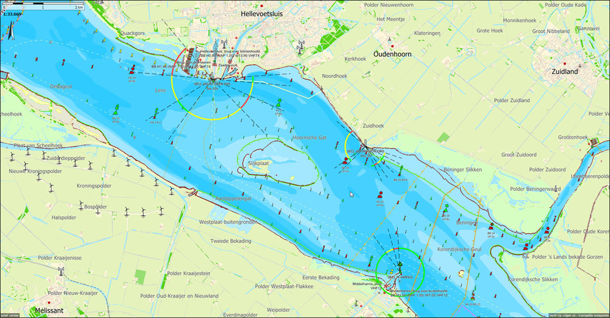
Sector lights in the Deltageul and the Hoornse gat. Only shown with WinGPS 6-2024 and subsequent versions. 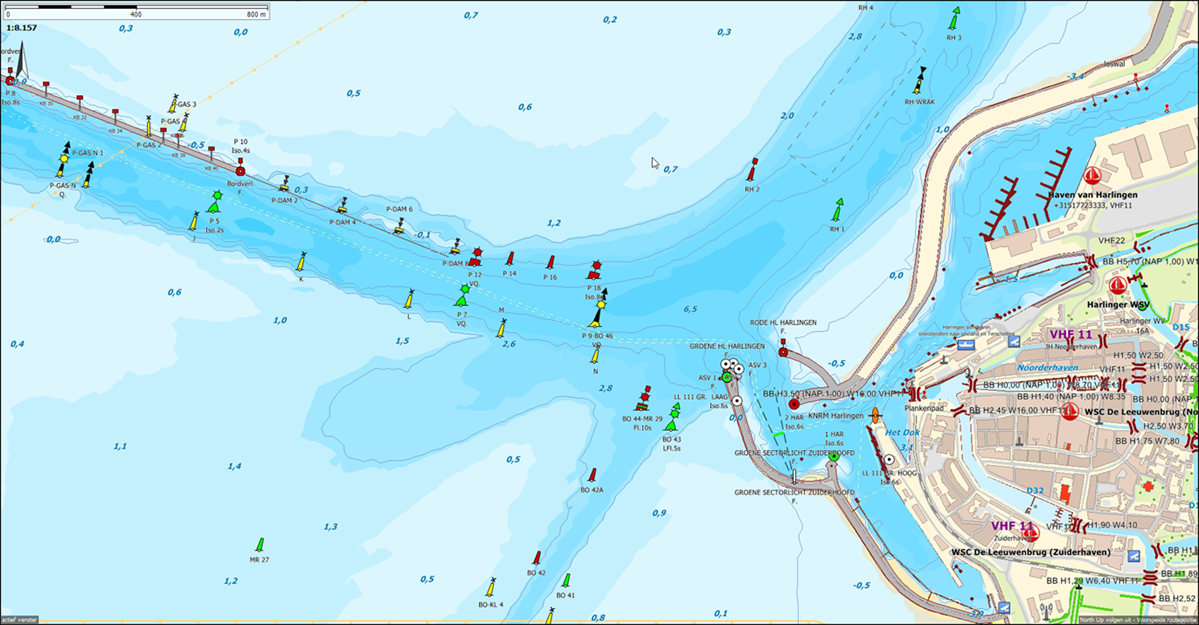
Recent depth image of the Wadden Sea near Harlingen based on IENC Wadden Sea (RWS Jan 2024). 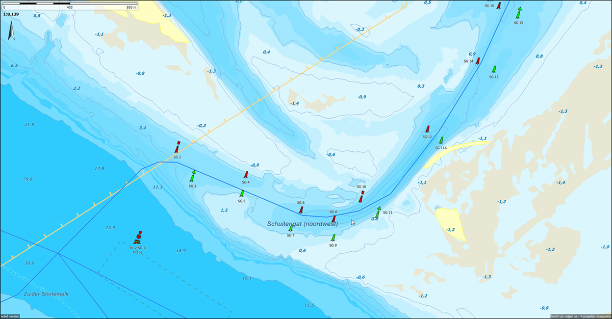
Detail of the changing Schuitengat in DKW Vaarkaart NL 2024. Note that the current buoyage has already shifted again. The route network here has not yet been updated and still runs above the red SG8 instead of below it. The buoyage of Vaarkaart Nederland is updated weekly, but that of the chart is not. The Schuitengat of the Stentec IENC Updateservice for WinGPS 6 2024 does correspond with the current buoyage. The IENC depth image of the Wadden Sea and Zeeland is updated weekly. However, the concrete on site may differ and is of course always decisive. Do you have any comments or feedback about this new chart? Then you can email this to helpdesk@stentec.com. |
- Details
| ENC charts in WinGPS 5 2018 |
|
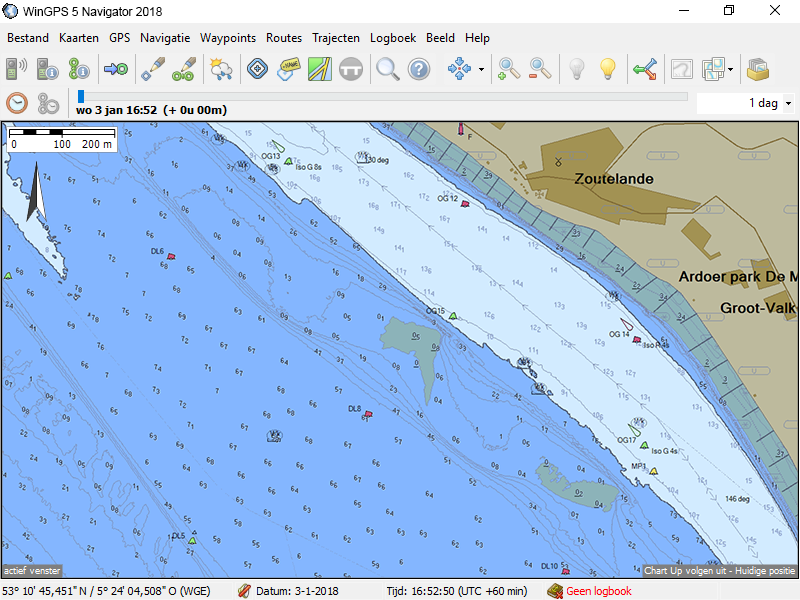
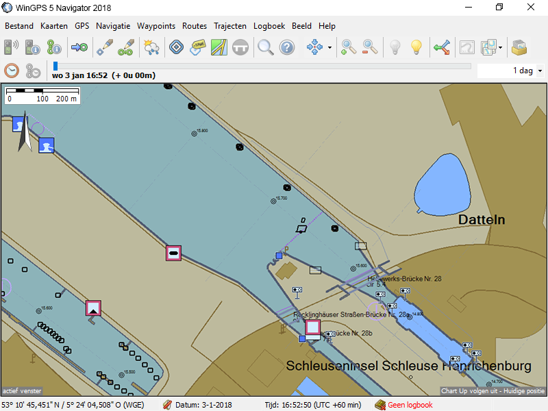
WinGPS 5 2018, expected for release in February, will receive a functionality which will enable the loading of ENC charts. During the Christmas holidays we were able to make a test version of WinGPS 5 with ENC charts loaded. Below you will find a few examples.
In the past, WinGPS could only read raster charts. These raster chart sets consisted of our own DKW charts and BSB charts from a.o. NOAA and NV-Verlag. The advantage of vector charts, comparing them to vector charts, is the relatively small file sizes and the ease with which updates could be processed and made available for our users. For example the weekly BaZ updates from the Dutch Hydrographic Services. In 2012 we produced our first hybrid chart set, the DKW Friesland. This was a raster chart based on the depth images from the Frysian province. On top of the chart images new layers were added with different waypoint groups, such as buoys, harbours, bridges, etc. These groups could be made visible separately from one another. Not only did the process of creating the chart sets evolve with this new style of chart sets, WinGPS too had to evolve to show all new available data. Updating WinGPS changed the waypoint group manager and made it possible for chart sets to overlap seemlessly thanks to new transparency settings for chart borders. A lot of rules for commercial inland shipping have been altered in regards to digital navigation. For example, in Germany it is now required to use inland ENC charts. This was the perfect opportunity for us to make the step to update WinGPS in to being able to read vector charts.
For the Netherlands, Belgium, France and Germany ENC charts are available for free. Soon, these charts will be able to be loaded in WinGPS 5 2018. It will then be possible to turn the different chart layers on or off, such as the depth lines and numbers. When you enter the depth of your ship, your coverage area will be shown in a different color. The development of WinGPS 5 2018 is still in full swing. We plan on showing a test version during Boot Holland 2018 in Leeuwarden. If you have any remarks or tips please contact us. |
News
- WinGPS 6-2024 Release
- DKW The Netherlands Inland 2024 in WinGPS 6
- DKW 1800 Serie 2024
- WinGPS 6 - 2024 - EN
- WinGPS 6 News!
- WinGPS 6 2022 is now available!
- NEW: Service Subscription and Premium Subscription
- Navigate carefree with an up-to-date system on board
- NEW: DKW The Netherlands 2022 edition
- The 2022 edition of WinGPS 5 for Windows is now available!


