


|
WinGPS Pro
If you not just want to plan routes but also want to connect your onboard equipment or sail on tidal waters you can choose WinGPS Pro as your professional navigation software.
|
|

GPS navigation on your laptop WinGPS Pro is an interactive route planner which can be installed on your Windows laptop. By connecting your onboard insstruments you can turn your laptop into a fully functional navigation system. Add a second monitor (for example a water proof touch screen) or install your charts on an Android tablet, making it possible to view the charts outside. |
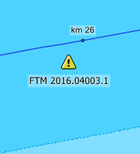
Multiple day planning with shipping notifications In WinGPS Pro is it possible to plan a route for multiple days along the inland waterways. Check your location on your desired 'stop times' and find a suitable harbour around that position to schedule a stay. Download the shipping notifications to avoid obstructions along your voyage. |
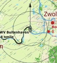
Chart windows and rotating charts It is possible to open multiple chart windows in WinGPS Pro. For example, use one window for a chart up view with rotating charts and a second window with the run-up to the destined harbour. |
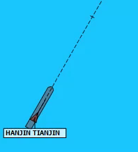
Safe navigation with AIS When you have an AIS device installed it is possible to connect it with WinGPS Pro. You will see all received AIS objects on your chart including name, MMSI number, call sign, dimensions, destination, cargo and of course the position, speed and course of the ship. Enter your CPA and WinGPS Pro will give off an alarm when you are on a collision course. You will immediately see the AIS object with call sign and can hail them immediately for a course change. It is possible to plot an expected course on the charts for your own ship and the other ships. AIS-XT, or AIS extrapolation technology, makes for a fluent motion of AIS ships on your chart which makes it easy while judging a traffic situation or when making a turn. With the time bar you can see which ships will be overtaken and which will be crossed. When zooming in or out the AIS target will be rescaled along with your own ship. Great when sailing along a river and you are about to go into a curve. You will immediately see which targets are pleasure ships and which are commercial vessels. |
GRIB files
Download GRIB files for the weather forecast of your area for the coming 7 days to prepare yourself for your voyage or regatta. Look ahead of time with the time bar to see how the weather will change.
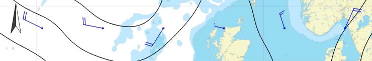
Currents, tides and water heights
In some areas, such as the Waddenzee, the waters are pretty changeable. With the annual current and tidal data from the NLTides, produced by the Dienst der Hydrografie, it is possible to look ahead of time during the calendar year to plan the best time to make the crossing.
A few days before your departure download the highly detailed current information, water heights and depth data throught the Kustfijn model. This model is based on data from Rijkswaterstaat, including current influences, such as backwater.
If you plan a voyage to the German Bight, Baltic sea, Northsea or English Channel you can download the actual current data through GRIB files. This data is provided by the BSH, the German hydrographic service, with information on the upcoming 2 to 3 days.
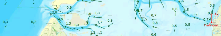
All above mentioned data can automatically be used during the planning of your routes. Enter the sea gauge of your ship download the latest water depths and plan your route; WinGPS Pro will automatically show you where you have enough depth under your kell and where you will dry out.
For the inland waterways NAP measuring stations have been added in WinGPS Pro. These stations show the actual water depths for the Dutch inland waterways, made available by Rijkswaterstaat. When you update your shipping notifications the NAP measuring stations will also be updates automatically.
Your reliable partner onboard and at home
A large advantage of WinGPS Pro is the possibility to install it on two Windows systems. Making it possible to plan your voyage at home on a large screen with all peace and comforts. Making your voyage even easier is printing the route overview.
During your voyage WinGPS Pro keeps track of a log of your route in which you can enter additional information. Your sailed tracks can be analyzed afterwards. When back at home you can print your logs and sailed tracks, send them to your crew or friends via e-mail or post them on your website or blog.
Stentecs digital water charts can be used in combination with WinGPS, also know as DKW charts. Make sure these charts are up to date before you start planning your routes and print your route overview and important chart details. This way you are well prepared for your journey!
For your information: WinGPS Pro has been prepared for deviation in your GPS by solar flares. Due to hightened solar activity solar flares will become more frequent which can cause large disruptions in GPS. WinGPS Pro has been adjusted to compensate for these deviations and will show your correct location.
|
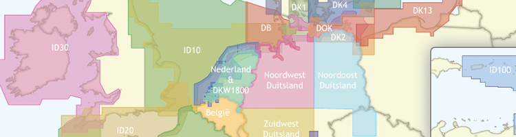
Digital water charts
|
|
System Requirements: |
Program release log: |
If you want to check if WinGPS Pro can be run on your system you can install the free version WinGPS Lite. When this version works without any problems WinGPS Navigator, Pro or Voyager will also be able to run on your system. You can download WinGPS Lite through this link.


