


Frequently asked questions
Click on a question to see the answer.
General
When choosing the navigation software, you can choose between WinGPS 5 and WinGPS Marine. WinGPS 5 is intended for use on a Windows device, such as a laptop or board PC. The advantage of this version with respect to the WinGPS Marine is that there is also a route planner including all bridge and lock information with pictures, operating hours and contact information. In addition, from WinGPS 5 Pro, you can connect an AIS, wind meter, depth meter, log, compass and an autopilot.
WinGPS Marine is intended for use on an Android device, such as a tablet or smartphone. This navigation software is slightly less extensive than WinGPS 5, but it is also a little less expensive. This app can be used on an Android device, for example a 10" tablet, but they are also available in larger sizes and waterproof.
If this didn't answer your question please contact our helpdesk
Can I connect my board instruments to WinGPS?
Yes, it is possible to connect board instruments to WinGPS 5 Pro and WinGPS Marine.
If you have one device you would like to connect, you can do this via the enclose cabling or via Wi-Fi or Bluetooth network. If you have multiple devices like AIS, GPS, wind meter, depth meter, log or compass, you can connect them all to a multiplexer. This multiplexer can be connected to the laptop or computer via Wi-Fi, Bluetooth or USB. If you want to connect it to the Android tablet, it must be connected to Wi-Fi or Bluetooth. All data from your instruments are then displayed in WinGPS.
If this didn't answer your question please contact our helpdesk
Yes, it is possible to connect AIS to WinGPS 5 Pro, WinGPS 5 Voyager, WinGPS Marine and to WinGPS Marine Plus.
Take a look on our website at 'hardware' for our AIS advice form. This tool can help you choose the right AIS device within a few steps.
You can connect AIS to WinGPS 5 Pro or Voyager with the enclosed cables, via internal Wifi or Bluetooth, or via a multiplexer. Make sure you have installed all the nessecary drivers. After the AIS is connected and your laptop recognizes the AIS, you will need to create a connection in WinGPS 5 Pro at 'instruments manager'.
You can connect AIS in WinGPS Marine or Marine Plus via internal Wifi or Bluetooth, or via a multiplexer. You don't have to install any drivers. Create a connection between the tablet and the AIS and select the right connetions in WinGPS Marine at 'settings - instruments'.
If this didn't answer your question please contact our helpdesk
WinGPS 5 (for Windows).
Can I install WinGPS 5 on both my laptop and tablet / smartphone?
It is not possible to install WinGPS 5 on your Android tablet or -smartphone. You can use WinGPS Marine for these devices. More information about WinGPS Marine for Android can be found here.
The DKW charts can be used on both your laptop and Android tablet or -smartphone. In total the charts can be installed on three different devices simultaneously.
If this didn't answer your question please contact our helpdesk
How do I install WinGPS 5 on my PC?
An explanation for the correct installation of WinGPS 5 can be found here.
If this didn't answer your question please contact our helpdesk
Can I create an (offline) backup of all my WinGPS software and charts?
An explanation for creating a back-up USB stick can be found here.
If this didn't answer your question please contact our helpdesk
I want to switch from WinGPS 4 to 5, can I get an upgrade?
No, it is not possible to upgrade from WinGPS 4 to 5. The upgrade discount only works when you are upgrading within the WinGPS 5 series. If you have WinGPS 4, you will have to purchase a full WinGPS 5 license.
If this didn't answer your question please contact our helpdesk
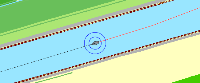
Can I remove the thin red line behind my boat on the chart?
The thin red line is the track you have sailed. Go to [ Tracks / Track manager] and un-check the box of the tracks, or remove them completely.
If this didn't answer your question please contact our helpdesk
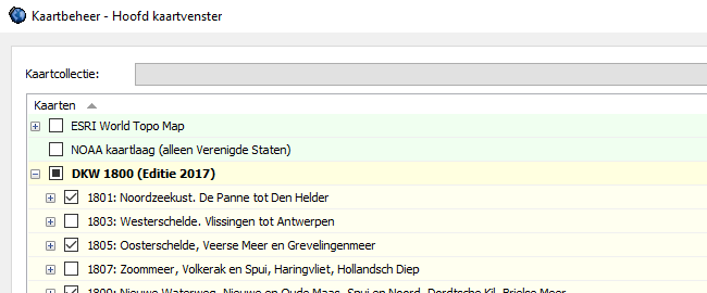
I don’t see a chart, or I see the wrong chart.
It is possible you selected the wrong charts, or the charts are on top of each other. Go to
If this didn't answer your question please contact our helpdesk
You can remove old charts by using the DKW Manager. Open the DKW Manager and click 'uninstall'. Select the charts you want to remove and click 'uninstall' again and then 'OK'.
If this didn't answer your question please contact our helpdesk
How can I center and lock my GPS position on the screen?
You can choose to lock the chart which will result in your GPS position moving over the chart, or you can choose to lock your GPS position and the chart will move underneath it. Click on the 'GPS tracking' button on the main toolbar to get the preferred setting.
The 'GPS tracking' button: 
If this didn't answer your question please contact our helpdesk
I don’t see my GPS cursor on my chart.
Is your GPS receiver connected to your computer? Is the communication (F3) turned on? Right click on the chart and go to 'GPS - Find GPS position'.
If this didn't answer your question please contact our helpdesk
My GPS position is not showing the correct ground course.
When not using a NMEA compass, and the course (HDG) of your ship is not showing the correct ground course, you can turn off the Leeway and Stream in the 'Navigation info' screen. This way the HDG will become equal to the COG.
If this didn't answer your question please contact our helpdesk
The computer sometimes freezes during an update.
Sometimes it may seem that the update stopped, and nothing appears to be happening on screen. In this case it could be possible that there is a blinking button on your Windows task bar below. In some cases Windows asks your permission to proceed with the update.
If this didn't answer your question please contact our helpdesk
My shown GPS position is incorrect.
There will always be one ship on your screen, this is your GPS cursor. It is possible that your GPS cursor is stationed at a place where you have already left. The cursor is also probably red. Starting the communication with your GPS can solve this, placing the GPS cursor at your current position. You can also right click on the chart and then go to 'GPS - set GPS position'.
If this didn't answer your question please contact our helpdesk
Which baudrate do I need to use?
Almost all NMEA devices use baudrate 4800. Except for AIS devices, these use baudrate 38400.
If this didn't answer your question please contact our helpdesk
Please send your comments, questions, user experience and possible error reports. This can contribute to the improvement of our navigation apps. Send an e-mail to: helpdesk@stentec.com


