


As an addition to WinGPS 5 on your on board laptop, Stentec has been developing navigation apps and digital charts for Android. With WinGPS Marine apps on your tablet or smartphone you can easily create an advantageous back up system. You can navigate on the same charts as your on board pc or navigation laptop.
Chart Apps in Google Play™
 Stentec’s new digital charts are usable in cross platform. This means it is usable on WinGPS 5 on your PC as well as Android tablets or smart phones. To be able to do so, you will need to login with your Stentec account.
The charts may be installed on 2 systems. A third activation is available as a back-up. After you login, the activation will be fully automatic. As of now, Google Play™ has 2014 editions of the following DKW chart apps:
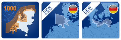
- DKW1800-series apps with weekly update service, meant to replace paper charts on your Android tablet.
- DKW German Bight and German Baltic Coast with free update in June.
- The UK1, English and Scottish East Coast including overview charts North Sea with updates in April, July and September.
These chart apps are sold for the same price as the download prices in our Stentec online shop. For example the DKW1811 chart app for €24,90. This chart comes with a free weekly update service and montly updates for depths on the chart. This is even cheaper than the paper chart set.
Free WinGPS™ Marine Lite app
 Besides this you may also find our free WinGPS™ Marine Lite app. The app comes with an OpenStreetmap (OSM)background chart which covers the world. After logging in to your account you can start downloading DKW chart sets on your tablet or smartphone.
 The following chart sets are currently supported
- DKW 1800 sets 2014 & 2013
- DKW UK1 - English & Scottish East Coast 2014
- DKW DB - German Bight 2014
- DKW DOK - German Baltic coast 2014
- DKW Imray ID20 2014
- DKW Friesland 2012
- DKW Belgium 2014
- DKW Vaarkaart Nederland 2014
- DKW IENC North & Rhein 2014
- DKW DK6 2014
DKW Vaarkaart Nederland 2014 is the only chart set equipped with an experimental Bridges & Locks database from the route network of WinGPS 5 2014. This will be perfected with an update for the Lite app which will allow the remaining inland chart sets to also have the database.

WinGPS™ Marine and WinGPS™ Marine+ for navigation on your tablet
The developments of these professional navigation apps are still in progress. The latest updates of the Lite app have also been added to these apps. The OSM charts seem to be a perfect background to GRIB files for wind and currents.
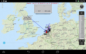
The latest WinGPS™ Marine+ test version shows AIS targets, GRIB files, external NMEA instruments and tidal information. Still missing is e.g. route planning. Creating this should not be a challenge.
Hopefully the next few weeks a test version may be released for testers. WinGPS™ Marine+ can be seen as an Android version of iNavX (for iOS) and will cost less than 100 Euro at Google Play™.


