


 With the release of the WinGPS Marine series, Stentec offers solutions for mobile navigation to everyone in water sports with an Android tablet or smartphone. Not only for sailors an motor boaters, but also for sloops, canoes, renters, charterers, divers, sport fishers and crew.
WinGPS Marine Plus is developed by Stentec and is the most complete navigation program for Android tablets and smartphones available for onboard. Safety, usability and reliability came first during the development of the app.
 7 Highlights usage on board
- Accurate navigation on high quality charts with almost exact buoy positions.
- Very user-friendly to create and edit routes and waypoints (on screen).
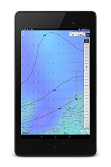
- Worldwide beautiful weather images animated from GRIB-files.
- Stream and wind predictions from Grib.us, NOAA, Norwegian Weather service, BSH.
- Optimal safety connected to a WIFI AIS transponder.
- Preventing collision is easy thanks to the relative speed vectors of all the AIS ships around you.
- Ideal as back-up or as independent navigation system and to connect to WinGPS 5 Pro or voyager on a board PC.
Free NLTides 2014 to use while sailing on the Dutch tidal waters. The new NLTides can be bought at the beginning of each year in the app.
 Specifications
- Following the chart with chart-up-modus. Also with moveable GPS-cursor for an optimal view.
- Reads the accurate DKW2-charts from Stentec, UKHO, BSH, Imray, Delius Klasing and OpenStreetMap and soon also NOAA BSB and charts created with DKW Builder.(from scans).
- Meteo & Tidals options to display GRIB-files and NLTides.
- Timeline to display the past (tracks) and future (routes, GRIB-files and tides).
- Advanced data plotter to display GRIB-files, NLTides and NMEA data.
- Reads NMEA messages from your GPS, AIS, wind meter, depth meter, log and compass through WIFI or Bluetooth.
- Easily manage the tracks, charts, routes and waypoints.
- AIS tracking list to quickly search for AIS ships and AIS target information.
- Man-overboard-button
Watch these youtube movies where Wouter Kuik gives a brief explanation about WinGPS Marine+. (In Dutch)
Updates with new options (under reservation)
- The new format Xtrack will be expanded with depth and wind along the tracks.
- The timeline will be connected to the boat cursor along the sailed track and route.
- The data plotter will be expanded for a display of speed, wind and depth along a Xtrack.
- Installing chart without a license code such as NOAA/BSB charts and DKW Builder charts.
- Course-up-modus will be added and the internal compass will be supported for rotating charts. Convenient for canoes and on the inland waters.


