


Stentec has released several important chart updates this week. These updates will ensure you can start your holiday as safe as possible. Besides the weekly NtM updates, we now also offer big updates for DKW German Bight and DKW German Baltic Coast. We have also released the new DKW1810 (based on the new paper edition) for licensees of the 2015 version.
DKW1810 2015
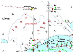
The most important changes in the new DKW1810 may be found in Harderwijk, where new marinas are being dug, The Ketelmeer where bouyage and depth has been changed and at the IJmeer where are gravel pits to build IJburg have been mapped.
This update is free for all users of DKW1800 Complete, DKW1800 North and DKW1810 2015 edition.
Don't have DKW1810 yet? Order it online!
DKW German Bight & German Baltic coast
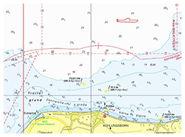
The update concerns 20 charts of the German Bight and 42 charts of German Baltic Coast. The BSH has caught up with Notices to Mariners (NfS) up until week 18. With this update the changes in the Jade-Weser estuary, the approach of Helgoland, the Elbe estuary, Trave estuary and the approach to Lübeck are processed. Mostly they concern changes in depth view and bouyage. Several windmill parks have been added in the Baltic Sea and military practice grounds have been expanded.
Don't have these charts yet? Order them in our online shop.
WinGPS 5 & WinGPS Marine
The charts mentioned above may be used in WinGPS 5 on your Windows-laptop / PC as well as in WinGPS Marine on your Android-tablet/ smartphone. After starting your program, you will automatically receive notice of the updates.


